Southern Upland Way 2003

Author: George Tod
This walk is illustrated with photographs. Click on small photo to enlarge in situ, or click caption to enlarge into new window.
Southern Upland Way 2003 |
||
|
Author: George TodThis walk is illustrated with photographs. Click on small photo to enlarge in situ, or click caption to enlarge into new window. |
|
| Part 2 - Stranraer to St John's Town of Dalry | ||

[Index of Walks]
[Previous]
[Top]
[Next]
[Index of Walks]
[Previous]
[Top]
[Next]
I had another good Scottish breakfast at 8 a.m., then called into Safeways for some things for lunch and at the cash point, as it would be quite a few days before I would reach a town of any reasonable size. To return to the Southern Upland Way, I decided to walk along the seafront on the A77 Ayr road, which runs nearly parallel with the A75 that I had come back on for the last mile yesterday. It was much more pleasant being able to look across the bay as I walked along, even though the road was gradually diverging from the route. On the beach there were an incredible number of shells, almost covering it in some places, and I was quite surprised to find swans and other wildfowl that I would only have expected to see on freshwater.
The forecast was not very good for the early part of the day, but it was not raining and was already starting to brighten up a little, which made a welcome change from yesterday. The maps in the guidebook did not extend to where I was now, so it was a matter of guesswork finding the way to where I wanted to be. As I started to come out of the town, I took a small road to the right and followed that until it eventually emerged onto the A75. About half a mile along the main road, which, at least, had a good pavement, I took another small road to the right and got back to quite near where I had left the route yesterday. I think that I covered about 3 miles getting there, rather than the 2 miles of the direct route, but I enjoyed the walk far more and I did not have a particularly long day ahead of me, so I didn't mind at all.
By this time there were a few patches of blue sky and it was getting quite hot, which was bringing out a few of the dreaded midges, but not enough to cause me much of a problem. The route soon entered a strip of mixed woodland next to the railway line and this made a pleasant change from walking along roads. The sunlight was streaming down through the trees, highlighting the bluebells and red campions, which were all around.
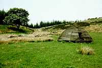
Passing quickly through the small village of Castle Kennedy, the route enters the grounds of the castle itself along a road lined with colourful rhododendrons, with a view across the White Loch to the ruins of the castle. The bank of the loch made an ideal place for a rest at 11 a.m. and as I sat there in the increasing patches of sunshine, I watched a heron perched not far away by the loch. Further along the loch was a turning off to the car park for the castle and its gardens, so I went up there hoping for a better view of the castle. From the car park, there was quite a good view of the castle from close quarters, without having to go into the grounds.
![]()
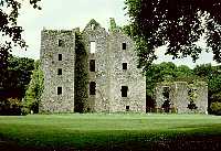 Castle Kennedy |
 Water of Luce |
Back on the route, it joined the road for a while before following a track uphill with views opening out more and more. Up the hill, after another short road section, the way follows a track leading to a forest. My guidebook talks about entering the forest, but I was pleased to find that things had changed since the book was written. Firstly, large areas of the forest had been felled, and secondly, the route had been diverted to take it around the perimeter of the forest so that, even when it is replanted, there will still be a view on one side. The landscape was that of a wild upland area with gentle hills punctuated by patches of forest. The weather was warm and sunny, so I stopped for an hour's sunbathing and had some lunch. It was very peaceful, with only the sound of the wind blowing gently through the trees, some birdsong, and the buzzing of a few flies, which were not too troublesome.
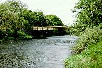
On the way down towards the Water of Luce, there was a short stretch where the path entered the edge of dense forest but, even then, it offered views through the trees for most of the way, so was not unpleasant. This change in forestry was mentioned in one of the leaflets that I picked up along the way. They have been trying to make the route more walker friendly, having realised that too much walking through forests puts many people off the walk. Nearer to the river, before crossing the railway line, there was woodland with large patches of bluebells to brighten the scene. A recently rebuilt footbridge takes the way over the Water of Luce and there, in the shelter of the valley, it was very hot, so I was glad when I climbed up Smithy Hill and found a little more breeze to keep me cool. At the road, I could have gone straight to my overnight accommodation in New Luce and then rejoined the route further along next day. However, as I did not have a long day's walk, I had decided to follow the way around New Luce and then turn back into the village from the other side so that I would not miss out any of the route.
![]()
 Moors past Smithy Hill |
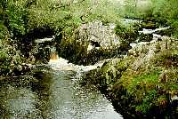 Loups of Barnshangan |
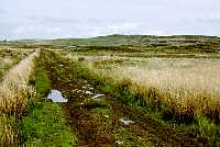
Up Smithy Hill, it was back to rough moorland after the verdant pastures of the valley and, after following a long, straight track for a couple of miles, I eventually neared the road at Barnshangan, where I took another rest, finishing off the last of my water. The weather was becoming more overcast, but still quite warm, as I went on to take a look at the Loups of Barnshangan, some waterfalls on the Cross Water of Luce. The peaty waters cascade through rocks into an almost black pool beneath a footbridge. It was then just a matter of walking about a mile and a half down the road to the Kenmuir Arms Hotel in New Luce, where I was spending the night.
I had the luxury of a bath to soak in when I arrived at the hotel and I then went down to the bar. There were a few people in the bar, mainly locals, and I had a few pints of Belhaven Best and a very tender lamb shank with mash from an extensive menu, even though I was the only one eating that night. A couple of chaps in the bar were schoolteachers who had arrived on their cycles and they consumed a number of pints of Guinness with gin chasers. I was surprised when they asked for gin and ended up with a glass of black liquid, but the word gin in these parts automatically means gin and coke. By the time they departed, I would have been surprised if they could manage to ride back home in a straight line, although they didn't seem too much the worse for wear, and it was obviously better than driving a car after the same amount of drink. In this remote place, they would be unlikely to meet up with any other road users on the way back in any case.
[Index of Walks]
[Previous]
[Top]
[Next]
It had rained heavily overnight, but I woke up to a bright morning with hazy sun. I had a long walk ahead of me of about 21 miles including my detours to and from accommodation, so I wanted to get off to a reasonably early start. After a good breakfast at 8 a.m., I managed to get started by 9 a.m. after chatting to the landlord, who was quite a young chap from the north east with a wife from Surrey together with her father, who was helping to run the business. They had only just taken the place over several months earlier and seemed to have been doing quite well, even through the winter, with the prospect of better trade in the summer.
I set off up the road back to where I had left the way the previous day and continued up the road, climbing steadily past Balmurrie farmhouse, with its beautiful garden, then onto a track and then a footpath over rough moorland. It was interesting to see how, on one side of the road was lush pasture, and on the other side rough moorland. In this remote area, with plenty of land to spare, much of the land which could have been developed into good grazing has been left untouched.
I came to a point where the path was not clearly defined, although there were a few marker posts from time to time. A recently erected fence kept me away from the route shown on the map, but there was a marker post on my side of the fence. After a short while, however, I realised that this was taking me in the wrong direction and I had to stop to take my bearings using my GPS. I was a few hundred yards off route, but it was not too difficult to make my way across to the correct path, albeit over some rather boggy ground. The weather had been rather warm and humid lower down, but higher up it was more pleasant , with hazy sun and a cool breeze.
A little further on, I entered the long forest section, but was pleased to find that there were broad clearings about 50 yards wide along the route for much of the way, which made the forest less oppressive, and a number of larger clearings and areas where felling had taken place opened things up even more. All in all, it is nowhere near so bad as it looks on the map, although the long forest tracks do tend to drag. The route varied from well made tracks to rather uneven and boggy paths over tussocky grass, which made rather heavy going but, in general, it was easy to make good progress.
At a shelter called the Beehive, I met a ranger, employed by the council, who was doing a photographic survey of this section of the route. I chatted to him for a while and commented on the lack of people walking at this time of year. He said that a lot more people walk later on and suffer badly from the midges, whereas at this time of year they are not much of a problem. The last entry in the visitors' book was from four days ago, which was about right for someone who had set off at the weekend.
![]()
 Beehive shelter |
 Loch Derry and Craig Airie Fell |
Further along were the Laggangarn standing stones, and beyond that, just off the route, the Wells of Rees, where lepers from Glenluce Abbey used to take the waters for their supposed curative properties. The ranger met up with me again, as he surveyed at the wells. These little items of interest helped to break up what would otherwise have been a rather monotonous forest walk.
Near Craig Airie Fell, where there had been a lot of tree felling, I was surprised to find that the route did not follow that shown in my guidebook, but doubled back towards the summit of the fell. This was a welcomed addition to the route, as the clear felling around about has opened up a full panorama from the summit, with Loch Derry below and a vast area of moorland and forest around in all directions. Unfortunately, the rather hazy conditions limited the view somewhat, but it still seemed to be the ideal spot for a lunch break and a spot of sunbathing with my boots off. I had to watch the time a bit, as I still had quite a long walk ahead of me and I didn't want to arrive too late at my B&B in Glentrool Village. It surprised me to find that in this remote location, with no civilisation for miles around, that there was good reception on my mobile phone. It seems that, even in remote places, there can still be a good signal if you are in line of sight with a distant transmitter, whereas lower down the signal is frequently blocked by small hills, even if you are quite close to a mast.
As I was about to set off again, the ranger met up with me yet again. He then passed me twice more in his pickup truck along the forest track further on. The next section of forest again had a wide clearing along the track, a number of other clearings, and views of the river from time to time, which helped to relieve the monotony of the walk a little, though it was still very tedious. After what seemed to be an eternity, I emerged onto the B7027 road from the forest road and, in another half mile, at last came to a path through the last stretch of forest before Bargrennan. Although the path was rather uneven and boggy, I was quite relieved to be on a path instead of a hard track or road. At this point I met the ranger again for the final time, as he was soon finishing for the day.
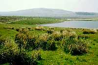
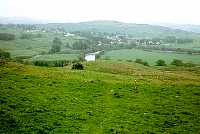
As I finally exited from the forest, I took a well earned break, as I had been walking for about 7 miles since my lunch-time stop. Continuing on my way, a further mile of road walking brought me to a path up the Hill of Ochiltree, with its fine views over the Loch of Fyntalloch and Loch Ochiltree, with a view also, though rather hazy, of the higher hills to the east. A path, rather boggy in places, leads down to the A714 road at Bargrennan. However, after hopping across a number of boggy bits, I must have missed a sign to turn left and carried straight on. When I realised this, I decided to drop down through Garchew Wood, in order to rejoin the rout. The wood itself was not much of a problem, but at the bottom I had to make my way through a very large area of extremely boggy ground, and only just managed to avoid sinking in over my boot tops on a few occasions. It was, therefore, with great relief that I rejoined the correct path and made my way into Bargrennan.
![]()
 Loch Ochiltree |
My B&B was about a mile and a half further along the road, in Glentrool Village, and I was pleased to see a sign pointing this diversion as an alternative route, picking up the way again via the visitor centre. This means that tomorrow I have about half a mile less than the 22.5 miles stated in the guidebook - still a long walk, but every bit less is all to the good. As I walked along the main A714 road a little way to pick up the minor road into Glentrool, I was rather dismayed to see that the sign said 2 miles to Glentrool Village when I reckoned that it should be little more than a mile, as I had already had enough of walking on long forest tracks and roads. Fortunately, the village came into sight before too long and I realised that they had got the sign wrong. I had a warm welcome from Morag at the B&B. She had wanted me to phone when I reached the main road, so that she could give me a lift, and was quite insistent that I have a lift down to the pub, which was a mile back down the road, for a meal. With some difficulty, I managed to persuade her that I really preferred to do everything on foot if it was at all possible, and a mile to the pub was nothing to worry about.
After a pot of tea and a bath to freshen me up, I set off back down the road towards the pub in the cooler evening temperature, which was far more pleasant than the rather oppressive heat earlier on. Despite the long walk earlier, I was feeling fully refreshed, and found it no effort at all getting down to the pub, especially with only having to carry myself and not a heavy pack. The bar did not have much ambience, but it was quite entertaining in there, as there were two couples having a lot of jovial banter between themselves and with the landlord and landlady, who were leaving on Sunday. I had a reasonable meal of haddock, chips and peas, together with a few pints of beer, which I needed to replace all the fluid I had lost in the hot day's walk.
When I got back to the B&B, Morag was telling me that the landlord had got on the wrong side of most of the locals and that they would be glad to see the back of him. She gave me a drink of her home-made sloe gin, and we had quite a long chat before I went off to bed to get some rest for another long day's walk.
[Index of Walks]
[Previous]
[Top]
[Next]
I had another good Scottish breakfast at 8 a.m. and was off, after packing up my things and chatting, at 9 a.m. As I left, Morag invited me to pick up a small piece of paper from a little dish on the table. It had a short quotation from the bible on each side. Again she wanted to give me a lift back to the route, but again I persuaded her that I didn't need one, as I was going via the visitor centre. From there, a path by the river eventually leads to a footbridge, where it meets the main route on the other side of the Water of Trool. This part of the walk, though in the forest, is very pleasant, as the river is nearby and the trees are far enough back for the hills on one side of the valley or the other to be seen for most of the way.
![]()
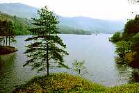 Loch Trool |
After a couple of miles, Loch Trool appears and there is a good view from the loch side. However, I soon found that this path petered out and that the main path climbed up a hill through the trees, a little way back. Unfortunately, the trees do obscure the view of the loch for some time. Nevertheless, I still enjoyed this bit of forest walking because the path twisted and turned and climbed up and down so that there was an ever changing view, even if it was sometimes just of more trees. This is so different from the long straight forest tracks and roads where there is virtually the same view for half a mile at a time and all you can think about is getting to the end of it. Further along, the loch becomes visible again through the trees and there are many more lovely vistas of the craggy hills, loch and trees. This section of the walk is by no means easy, but it was the most enjoyable so far, and I was hoping that this improvement in the scenery would continue.
I stopped for a break at 11 a.m. just past the head of Loch Trool, where I drank half a litre of water straight down, as it was another warm day with hazy sunshine, although there was a cool, refreshing breeze from time to time. Looking at the hills around, I started thinking that the route would have been better following the hilltops rather than keeping to the valley, but considering the long distance between accommodation, perhaps it would be too much to include a lot more climbing, which would make for slower progress.
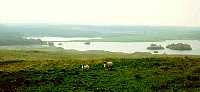
At the head of Loch Trool, the path climbs up fairly steeply for a way before dropping back down to Glenhead Burn. At this point there was a sign showing this section of the Southern Upland Way together with an alternative route offering better views. A solid red line showed the Southern Upland Way and there was also a dotted line looping away for a couple of miles. I took the route shown by the dotted line and was rather disappointed to find that, after a while it ended up on a long forest track climbing up a high valley with no view at all. Even when it emerged from the forest further up, there was still not much of a view. As I reached the top of the hill, there was another notice board showing the same map at the other end of the alternative route. On closer examination, I found that the dotted route was actually the original route and that the alternative route was the one that was fully waymarked and shown as the official route on the map. The normal thing that is done in these circumstances is to have a sign saying that there is a route change and asking people to follow the waymarkers. This was all very confusing and meant that I missed out on the better views.
![]()
 Loch Dee |
The wide track continued on past Loch Dee but the scenery, though still good, was not as attractive as that of Glen Trool, and the forest track became rather tedious although again, due to felling and replanting, the views over Loch Dee and the surrounding hills were not obscured for most of the way. Just past Loch Dee, I took a lunch break. At lunch breaks, weather permitting, I like to take off my boots and socks to give my feet a proper rest and a good airing. It also helps to dry out any dampness that may have been building up. A small blister had been building up under my right heel and this was caused by the foam rubber of my Sorbothane insoles having broken up causing it to rub. I took this opportunity to cut away some of the offending rubber, and also to burst the blister. Apart from this minor problem, my feet were doing very well and giving me less problem than on many long walks.
I set off again at 1.45 p.m. and soon found that the conifers took over and I was faced with another long trudge on wide forest tracks without much of a view. In one or two places, large areas of trees had been felled, opening up wider views of the hills around and about, but this still left all the unsightly debris left from the felling operations. Eventually, after crossing the River Dee, I came to a sign put up by Forest Enterprises which said 'No unauthorised persons beyond this point'. There was no diversion marked, nor was there any sight or sound of anyone working in the area, so I just carried on, keeping an eye out for anything that might be happening. After about 100 yards, I came to a similar sign facing in the opposite direction, and all that I could see between the two were some new stone chippings that had been spread on the track.
Eventually, Clatteringshaws Loch came into sight and relieved the monotony of the walk for a while, before the route turned away through more forestry before finally emerging into open country. Looking at the guidebook, I had about 6 or 7 miles to go. It does annoy me that these OS guides to National Trails are lacking in the most basic information that a walker requires. To me, one of the most important things I want to know, after knowing that I am on the right route, is how far I have left to go, so that I know how quickly I have to walk and how many rest stops I can take. Most guidebooks written as such by real walkers include this information as a matter of course, generally by putting a little circle every mile along the route with the distance from the start, making it very easy to see how far it is to your next destination. They often also include the amount of ascent in each section of the walk, so you can see how difficult it is likely to be. However, to the Ordnance Survey, these things seem of no importance and they would far rather include lots of information that is of little relevance to a walker than include things of genuine practical value.
I stopped for a short break and a drink of water before setting off at 4.10 p.m. on the last stretch to St John's Town of Dalry. It was a relief to be out, at last, into open country again, even though it was on a rather nasty path along a sloping hillside badly churned up by cattle. It did improve after a while before joining a track and then a road for the next few miles. I was feeling rather footsore now and looking forward to reaching my destination for the night. I made one more quick stop for water and a short rest at 5.30 p.m. The weather had gradually changed from hazy sunshine to cloud, which had, at least, brought down the temperature, making it pleasantly cool. After following road and the stream for a while, the way took a path through fields and up Waterside Hill, which overlooks St John's Town of Dalry. As I entered the field I found a hefty bull standing right in the path. He was accompanied by several heifers, so was less liable to be a danger, but I didn't want to take any chances. I waited for a while hoping that he would move, but then gradually made my way around him. He kept eyeing me up and down but seemed contented, as he kept chewing the grass, so I was able to get cautiously past and on my way.
![]()
 St John's Town of Dalry from Hill |
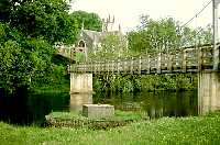 Footbridge to St John's Town of Dalry |
There was a steady climb up the hill, but I didn't mind that, as it made a pleasant change and opened up views of the rolling hills around the area, as well as of the town itself. A short walk down the hill took me to the road, where I found another route change to take a path by the river rather than having to follow the road for a while. The riverside path leads to a footbridge over the river by the church, which is right by the town centre. My accommodation at the Lochinvar Hotel was quite close and it was not long before I was soaking in a nice hot bath before going down to the bar for a well earned pint or two and a bar meal. I had Cumberland sausage with mash and vegetables, which would have been nicer had it been warmed up properly, then followed by trifle.
The cloud had cleared making it a warm sunny evening, so I had a wander around the church and down by the river, where a few people were fishing. I didn't go very far, as I was still feeling the effects of the 22 mile walk on top of the long walk of the previous day. The river flow here is affected by the hydroelectric power station a short way upstream, which can release sudden heavy bursts of water at times of peak electricity demand. This must have been the case when I came by earlier, as the river was flowing much more rapidly than now. The water level can rise suddenly and there are warning notices to this effect.
The other main accommodation provider in the town is the Clachen Inn, which is home to www.southernuplandway.com. The room prices tend to be more expensive than the Lochinvar Hotel, although they do offer discounts for those doing the whole Southern Upland Way. It seemed very lively in the bar, and it would have been nice to go in, but I was still feeling a bit too full from my meal to have another pint. I went back to my room and watched TV for a while and caught a weather forecast which said that there was a band of rain spreading across but then it would be quite good for the next few days.
[Index of Walks]
[Previous]
[Top]
[Next]