Southern Upland Way 2003

Author: George Tod
This walk is illustrated with photographs. Click on small photo to enlarge in situ, or click caption to enlarge into new window.
Southern Upland Way 2003 |
||
|
Author: George TodThis walk is illustrated with photographs. Click on small photo to enlarge in situ, or click caption to enlarge into new window. |
|
| Part 1 - Preparation and Travel to Stranraer | ||

[Index of Walks]
[Previous]
[Top]
[Next]
The Southern Upland Way is a 212 mile National Trail across Scotland from Portpatrick near Stranraer on the western coast to Cockburnspath, SE of Edinburgh on the eastern coast. It is a walk that I have had a mind to do for some time but I have been put off by the fact there are some very long sections with no apparent accommodation and it has always seemed to be a walk that was more suited to backpacking than to B&Bs. However, although the walk does go through some very remote country, having read one or two accounts of the walk on the Internet, I realised that it is possible to find accommodation along the route. If the worst comes to the worst, there are B&Bs who will pick up walkers from pre-arranged points and drop them off again the next day, and it is also possible to find some very limited accommodation even in the most remote areas. With this reassurance in mind, I decided that it may be worth giving it a try, and put the guidebook on my Christmas present list.
The guidebook I chose was an Ordnance Survey Recreational Path Guide of The Southern Upland Way by Anthony Burton (ISBN 1 85410 455 1) complete with 1:25,000 OS map sections and with the whole 212 mile route included in the one volume. This makes a change from some National Trails which need two volumes to cover routes of lesser distance due to the inclusion of too much unnecessary material such as circular walks around various parts of the route and large amounts of historical and environmental information. This is all well and good in the right place, but is not ideally suited to a guidebook to be used primarily for route finding.
When the guidebook arrived and I started browsing through, I almost threw it away in disgust. Page after page of the map sections showed mile upon mile of forest walking, which is far from what I was looking for in the walk. However, on reading through the guide it claimed that this was not as bad as it looked, as many of these forests have been either newly planted or have been felled, whilst others still manage to afford some views through clearings or across lochs. Somewhat, but not altogether pacified by this, and still being attracted by some of the wild, open country further on, I decided that I would, after all, give it a try.
[Index of Walks]
[Previous]
[Top]
[Next]
The next thing was to try and plan my stops along the route, and work out how to break up some of the excessively long sections of 27 miles or more shown in the guidebook. The first thing that came to light was that there were some discrepancies in the distances quoted in the book. The 'Distance Checklist' near the front of the book shows Bargrennan to St John's Town of Dalry as 27.5 miles or 36 km, whereas the relevant chapter of the book shows it as 22.5 miles or 31 km. This does not inspire confidence and one would expect better of the Ordnance Survey. I eventually worked out that 22.5 miles or 36 km was what should have been printed, but it made me wonder if I could trust the rest of the mileages. I would hope that later editions of the book will have this corrected or, at least have an errata sheet included. Having sorted out this confusion, the next thing to do was to find an accommodation list. The main guide appears to be The Southern Upland Way Accommodation Guide, a free publication available from Tourist Information Centres along the way and also through the Ramblers' Association. I also found a copy of this in pdf format on the Internet at www.southernuplandway.com and downloaded the cumbersome 1.3 Mb file. Why anyone puts pdf files on the Internet is beyond me, as they are generally totally unsuitable for web browsing, being about ten times as large as an equivalent html file, but they seem to be much loved by government departments and academic institutions alike. They may be fine for desktop publishing and may be OK with broadband, but with a dial-up modem they are a pain.
However, at least I obtained an accommodation list and was able to start planning suitable overnight stops. The main causes for concern were the sections from Castle Kennedy to Bargrennan (26.5 miles), Bargrennan to St John's Town of Dalry (22.5 miles), St John's Town of Dalry to Sanquhar (25 miles) and Melrose to Longformacus (25 miles). Some of these sections were quite easy to split, albeit not into equal halves, by diverting a little off the route, but the one presenting most difficulty was the section from St John's Town of Dalry to Sanquhar, which has little habitation along the way. There is, however, a farmhouse close to the route about 7 miles from St John's Town of Dalry, and I managed to book accommodation there to break up that section. I didn't have too many problems booking most of the accommodation, except for the area around Melrose, which has plenty of B&Bs all of which were full. After a considerable amount of phoning around, I eventually managed to find a place in nearby Darnick, which had a room for me.
The final schedule still left me with very unevenly spaced stops with four days going between 20 and 22 miles including diversions to accommodation, but also with some days of only 7, 8 and 10 miles. This was far from ideal, but the best I could do in the circumstances through such remote areas. On my journey to the start, I decided not to head right to Portpatrick, but to stay overnight at Stranraer, travel to Portpatrick in the morning and walk back to Stranraer again for a second night in the same B&B. This meant that if my train was late arriving, I would not be stuck trying to get to my B&B and also that I could do the first day's walk with a lighter pack.
Travel to the start and from the finish was only feasible by rail, and even that was with two changes on each journey, making each of them take most of a day. I booked tickets on-line, enabling to get a Saver ticket on the outward journey, but not coming back. Apex tickets, although a price was quoted, for some reason were not available on either journey, so I had to make do with higher priced fares.
I normally manage to do quite a bit of regular walking and fit in a mountain walk around Snowdonia or the Clwydian Range every week or two, so I didn't need to worry about training for the walk. I had bought a new pair of boots just before Christmas and these were nicely broken in and quite comfortable, so everything seemed to be going fine until I went for a walk less than three weeks from when I was due to start the Southern Upland Way and found that one foot quickly became soaking wet. What had happened was, on a previous walk in dry conditions, I had stepped on something sharp with the arch of my foot and this had punctured the sole of my boot where it was weakened by the makers name tag recessed into the rubber. It looked as if it might be possible to repair in some way but I didn't want to risk setting off on a long walk unsure as to whether the repair would work. This meant that I had to rush out and buy a new pair of boots with very little time to break them in. I have rather awkwardly shaped feet but, fortunately, I managed to find a pair of Montrail boots that fitted quite well and felt comfortable right from the start. They are of similar construction to fabric boots I have had with GoreTex lining and plenty of padding, but with a more substantial leather outer which, I hoped would keep out the water more than fabric would. A few walks in the boots proved them to be as comfortable as I had first thought, so I felt quite relieved about starting the walk. The only thing I needed to do was to provide them with some sort of arch support for my high instep, otherwise I knew I would start getting my usual problems of pains in the balls of my feet after a few days of walking. Rather than just stuffing something under the insole, as I have sometimes done in the past, I decided to make something more substantial using car body filler which I put into small polythene bags inside my boots so that it would be moulded to the shape of my instep whilst it set. This seemed to work quite well and, after a bit of trimming here and there to get the best fit, I inserted these supports underneath some Sorbothane insoles, hoping that this would give me the best possible comfort for the walk.
Having checked out all the things I needed, and a few more that I didn't need, in my rucksack, it weighed about 20 lbs. Without food or water for the day. This is rather more than I would have liked, but comes about from adding extra little items from walk to walk and thinking "Oh, another half pound won't make too much difference." I had packed a few more items for cold weather than I normally carry, with the walk being further north, and I had also added insect repellent in case of problems with midges.
[Index of Walks]
[Previous]
[Top]
[Next]
After saying my farewells, I had a lift to the station and commenced my journey to Stranraer. All went smoothly with my connections and the weather was fine as I travelled on the final leg of the journey from Carlisle. The train takes a roundabout route that approaches Stranraer from the north east, having crossed the Southern Upland Way at Sanquhar, which I would reach six days into the walk. The train was not very full until it reached Ayr, where there was a mass influx of people, many of them foreign, although I couldn't quite make out what nationality they were. Many were carrying large rucksacks and I wondered if they were heading for the Southern Upland Way. Ayr is the nearest station to Prestwick airport, so that is obviously from where they had arrived.
On the way down the coast, I was able to get a feel for the landscape with wide sweeping hills and forests, although the higher hills were shrouded in mist. Out from the coast the rocky island of Ailsa Craig could be seen in places. Further down towards Stranraer, the land was considerably lower and largely grazed by cattle. Having travelled a considerably way with the coast on my right, Luce Bay on the southern coast came into sight on my left as the train made its final approach to Stranraer. As everyone disgorged from the train, I found that I was the only one headed towards the town; everyone else made for the ferry terminal and the boat to Belfast. So much for me thinking that they were Southern Upland Way walkers.
After finding my B&B opposite Safeways and watching the weather forecast, I went down to the bus stop to find out the times of busses to Portpatrick in the morning. There was roughly a two hourly service with one conveniently timed at 8.58, just right for breakfast at 8.00. Looking around Stranraer for something to eat, I chanced on the Arkhouse Inn where they were serving bar meals, so I had a home made steak pie and some McEwans 80/- beer; not real ale, as there tends to be less of that around in Scotland, but nevertheless quite palatable.
[Index of Walks]
[Previous]
[Top]
[Next]
I woke up to a rather dreary morning with mist and some light rain. My plan was to take the bus to the start at Portpatrick, walk along the route, skirting around Stranraer to within a mile of Castle Kennedy and then walk the two miles back to my B&B along an old military road shown on the map. The next day I could rejoin the route by retracing my steps. This would mean that I would have a fairly easy day, as I could leave a lot of my rucksack contents behind and have a walk of a little over 14 miles. I had a full Scottish breakfast of bacon, egg, two sausages, tomato, mushrooms and fried soda bread, which was more than enough to set me up for the day.
After calling at Safeways for a few things for my packed lunch, I got to the bus stop in good time, only to find a bus there with two mechanics unsuccessfully trying to repair it. Not knowing whether this was the bus I was supposed to catch, I was quite relieved when another bus came along destined for Portpatrick and transported me there through the mist and rain.
![]()
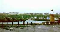 Portpatrick Harbour |
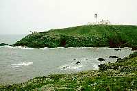 Killantringan Lighthouse |
Portpatrick is a pleasant little town with its harbour, lighthouse and rugged coastal scenery. It was raining sufficiently for me to put on my waterproofs as I wandered around the harbour and set off past the Southern Upland Way notice board towards the cliffs. The coastal scenery was interesting, despite the poor weather, although any chance of seeing Northern Ireland was completely out of the question. Red campions, bluebells and other wild flowers lined the way to add a touch of colour and brightened up the scene.
After a mile or so, the rain had eased to light drizzle and I was already feeling hot and stuffy in my waterproofs and the clothes in which I had travelled from Stranraer, so I stopped to change into shorts. Past the fine looking Killantringan lighthouse, the way turns away from the coast to follow minor roads for a few miles with not a great deal to see, especially in the dreary, misty conditions. However, I did come across a roe deer, which came across a field and into the road, about 100 yards ahead before turning around and running back down the field.
At Mullock Hill, there is quite a nice view of Knockquhassen Reservoir but there was no possibility of seeing the peaks of Arran and Ailsa Craig, which are visible on a clear day. I stopped for lunch by the reservoir, where it was still misty with a little drizzle that started to turn to showers of rain after a while, forcing me to put on my waterproof jacket. With the clearing of the mist, the views opened up more with a visibility of about 10 miles. It was not long before the way reverted to minor roads for most of the remaining walk. There were views, after a while, over Stranraer with its ferries for Northern Ireland, and views of some low hills to the east, in the direction of tomorrow's walk. However, the road walking became very tedious, relieved only by a few limited views round about and some interesting flora on the verges and in the hedgerows. Traffic was not a problem, there being only a few cars that I encountered all day, apart from those on the very short stretch of the walk along the main A77 road, which was quite busy. The main problem with the road walking was that much of it was along straight stretches of road with little change of scenery, and this tends to make a walk drag.
A little way before I reached the point where I was to double back into Stranraer, I stopped by a small loch in the forest to take advantage of the shelter from the trees while I had a short rest at 3 p.m. I took this opportunity to look at some of the leaflets I had picked up earlier. At various points along the way, there are leaflet boxes with information on the geology, wildlife, place names, accommodation and the route as well as one about 'waymerks'. A number of local artists have created 'kists' out of a variety of materials and partially hidden them along the way. In each kist is a large number of merks, minted from lead or copper and the size of a coin with a different design for each of 13 locations. The idea is to collect one from each kist that you find along the way.
The rain was a little heavier as I made my way to meet up with one of the old military roads leading back towards Stranraer, but it was not enough to get me particularly wet. The minor road met up with the busy A75 for the rest of the way, but at least there was a footpath most of the way. I was the cause of some intrigue to a young lad, who was finishing his paper round on his bike. He followed me along for quite a way, querying whether I was cold in shorts and asking why I should want to be in Scotland and why I should want to walk to the opposite coast. Eventually, he went on his way, and I continued on, arriving at my B&B by 4.30 p.m. after a fairly easy, but uninspiring day's walk.
After a shower and cup of tea, I watched the news and weather on TV before heading back to the Arkhouse Inn for a few pints of McEwans 80/- and a meal of enchiladas, which was very good and filling. Even after a day's walking, I couldn't manage all the chips and coleslaw that went with it.
[Index of Walks]
[Previous]
[Top]
[Next]