The Cambrian Way 2005

Author: George Tod
This walk is illustrated with photographs. Click on small photo to enlarge in situ, or click caption to enlarge into new window.
The Cambrian Way 2005 |
||
|
Author: George TodThis walk is illustrated with photographs. Click on small photo to enlarge in situ, or click caption to enlarge into new window. |
|
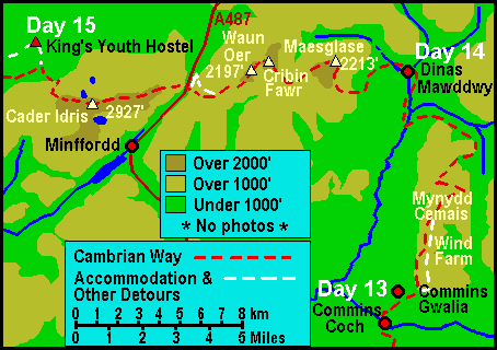
| Part 8 - Days 14 and 15 - Commins Coch to Penmaenpool | ||

[Index of Walks]
[Previous]
[Top]
[Next]
[Index of Walks]
[Previous]
[Top]
[Next]
The weather forecast proved to be correct, and I awoke to steady rainfall. My vegetarian breakfast consisted of muesli, boiled eggs and lovely home-made bread, jams and marmalade. For packed lunch I had sandwiches made from the same bread with cheese and pickle. The other two set off at 8.45 to get down to Machynlleth for 9.00 to meet their taxi, but I was in no rush, as I had less than 12 miles to go and I was hoping that the rain might pass over. Instead of the weather improving, the cloud drifted further down the hillside, so I decided that I would just have to pack everything carefully and set off into the rain.
The route started off along Glyndwr's Way until that continued round the bottom of the hillside whereas the Cambrian Way headed up for Mynydd y Cemaes. I got onto a good track which was not quite the right route, as it headed up the mountain at a different angle, but I stayed on it for some way instead of trying to follow some indistinct and uneven footpath. Further up, I took a smaller path, which led to the summit and from there I picked up the wind farm access road. The proper route bypasses the summit and follows the edge of the mountain ridge for some way, presumably with better views from there on a good day but, as the visibility was limited to about 50 yards, I found it easier just to walk through the wind farm on the nice even road surface. My ankle had recovered considerably after the easy day yesterday, so the more even walking I could do, the more it might continue to improve.
The walking was easy along the very flat mountain top, but there was little of interest to pass the time other than counting off the wind turbines to check my progress. Even though I went quite close to them, I could hear them better than I could see them, with just a vague shape being visible for a short time through the mist. I also checked my progress with my GPS, until it was time to head back down from the northern end of the ridge. Here the navigation got a little more difficult, as the last few turbines shown on my O.S. map either didn't exist, or were not in the marked position, but my GPS helped me to find my way down by the side of the forest. This was over rough ground, with no visible path on the ground until I came to the place where I turned into the forest. The route was then waymarked for quite a way, though the path itself was uneven and very boggy in parts, to such an extent that I had water lapping over the tops of my boots at times. This ensured that my feet, which were already getting wet, got completely saturated.
The waymarked bridleway then ascended Esgair Ddu at an angle up the hillside with a gradual slope. Although it is uncommon around here to find a waymarked route, there was a typical example of the disregard for rights of way, as there was a padlocked gate across the bridleway. Further along, the waymarking pointed straight up the steep hillside, where there was no path, whilst the bridleway seemed to go on ahead. I was tempted to carry straight on, but my O.S. map also showed the path going the way that the arrow was pointing, so off I went over rough ground, up the steep hillside. At the top it levelled out onto a horribly rough and boggy plateau. I had to keep using my GPS to find my position, as I spent a lot of time meandering around in the mist, trying to avoid the worst of the boggy areas, so I always seemed to be off course. Eventually, I managed to find a route down the hillside in roughly the right place and, dropping down below the mist for the first time, was able to see a footpath not far away, to take me down the rest of the way. I had a strong suspicion that, had I continued along the bridleway instead of climbing up the hill, I would have reached this footpath by a much easier route. Looking at the map, the distance I had covered over the plateau was not very much, but with the horrible walking conditions and the feeling of being lost, it seemed ten times as far. It also threatened to undo all the good that had been done for my ankle.
Now, at last, I was down onto a farm track, which made life a little easier. I would have liked to have stopped for a rest, but there was nowhere offering shelter from the rain, so I just had to keep on going. The track ran round the hillside, part of the way up, and I am sure it would have given some good views on a better day, but today there was little to see other than sheets of rain and mist over the hills. Further along, the track started to climb up the hillside, which worried me a little, as I didn't expect to have to climb back up again, at least not to any great extent. After a short way, there was a junction and it looked as if there should have been a track running alongside a wall, though it was all very overgrown, so the only route seemed to be the one going up the steep incline. A bit of the way up, I could then see that there actually was a route by the wall further along. By the looks of it, other walkers had found the same problem, as there was a path going back down again to meet the track. Eventually, I reached a sheltered spot under some trees by a stream where I could stop for a break. It was not the best place, but I had been walking for four hours and needed a rest. I ate my sandwiches and a few other things with a little shelter from the rain, but with large drops of water dripping from the trees above I was starting to feel very cold. It wasn't one of the highlights of the walk, to say the least.
Soon I came onto a surfaced road, which at least made the walking easier, even though the weather was still bad. The road eventually came out near the Brigands' Inn, which looked like a good place to get some shelter and warmth for a little break. Although there were boards advertising afternoon tea, the lights were off everywhere and it didn't look much like being open. No doubt if I had gone in and asked, I could have got something, but in my bedraggled state, I decided not to bother and pressed on. A road sign said 'Dinas Mawddwy 1M', but the route via the other side of the river is two and a half miles. As I came close to the second river crossing, I passed by a mill shop with a cafe, so I stopped in the entrance to take off my waterproofs and boots, then went inside leaving wet footprints along the floor from my socks, only to find that they had a power cut and were not even able to offer a pot of tea. I set off again without my waterproofs, as it had just about stopped raining, not that it mattered much, as every stitch of my clothing was soaking wet.
When I reached the Red Lion, I rang the door bell, but nobody responded, and I couldn't see any sign of life when I walked around to the back, so I decided the best thing was to telephone. I had no signal on my mobile, so I walked right down to the far end of the village to where a telephone was shown on the map. I got through and the chap who answered said he had not heard the bell because he was in a flat around at the back, but he would look out for me when I returned after the ten or fifteen minute walk. At last I was inside out of the foul weather and able to have a long soak in a hot bath, which was a change from a long soak from a cold shower that I had endured all day! I then washed out all my things that were already soaking wet, as I had nothing to lose, and hung them around my room to dry.
It was about 6 pm when I went back down to the bar and asked if they had a payphone, as I needed to ring home, and was told that the nearest one was down the road. I didn't fancy another long trek to the other end of the village, but was informed that there was one much nearer - I had not noticed it earlier, as it was rather hidden by bushes. That seen to, it was back to the bar for some very good Worthington's bitter and a pork casserole with vegetables and new potatoes, which was also very good. The bar was quite lively right from opening time, and it was good to relax and feel warm and dry after such a miserable day. The bar had a huge collection of horse brasses and other brass ornaments and was everything a good village pub should be; warm and friendly with good beer and good food, making it the social centre of the village. This, at least, helped to make up for all my misfortunes through the day.
[Index of Walks]
[Previous]
[Top]
[Next]
Breakfast was at 8.30, so I got up at 8.00 and looked at all my washing that was still quite wet. The weather outside was not too good with the cloud still low and some light rain. The forecast, however, was for highs of 23 degrees after a wet start. I was the only resident and sat at a table in the large dining room looking out at the rain whilst eating a good breakfast. It was obvious that I would have to pack everything well against the rain again, and there was no point in putting on dry things, as they would only get wet, so I donned my damp walking gear with damp socks in my wet boots and put on my waterproofs as well.
It was 9.35 as I set off up the road to where the waymarked path runs up through the forestry plantation. The climb was steep in parts, and it was well worth having on my waterproofs because of the wet undergrowth that I kept brushing against. Although it was wet, it was not cold, so I soon started to sweat with the climb, which meant that by the time I emerged from the forest and embarked upon the more level path round the hillside, I was glad to remove my waterproofs and let the air get to my body.
The path more or less follows a contour round the steeply sloping hillside, and is not very wide, so it was a bit like walking a tightrope trying to keep both feet within the path at the same time. There would have been some good views across the valley were it not for the mist, though the rain had just about stopped leaving only the drizzly dampness from the mist. After a mile or so, and a few awkward bits of path, it started to ascend steeply. I could hear the waterfall nearby but could not see it as the route went onwards and upwards. By now my boots were starting to get very wet from brushing against wet grass and I was accompanied by a squelching noise at every footstep. Further along the path crossed a stream that fed one of the waterfalls, and I could see the water cascading down the steep hillside into the mist below. Route finding was not difficult, as a reasonably defined path made its way alongside the steep cliff side to the right, all the way round the edge of mountain. From then on it was just a matter of following the path, with occasional checks of GPS and map to make sure I was still on track. I kept expecting the mist to lift at any time and was heartened when, occasionally, weak sunshine filtered through and added a touch of warmth. It was not cold, which is why I had left off my waterproofs even though I was getting rather wet from the mist.
After about three hours' walking, I was getting tired and in need of a break, so I stopped for lunch sitting on a stile, which was about the only place other than the wet ground on which to sit. Further on, I eventually got to the point where I had to turn off to drop steeply down towards the A487 road on the way to Cader Idris. So far today I had passed over various mountain peaks and never had a view of more than about 50 yards, but I was still hopeful that the mist would clear before this final, and highest, peak of the day. The path I was on seemed to be taking me somewhat off route, so I headed across rough ground for a way until I met up with a minor road. As I squelched down the road, I could see splashes of water coming out of the tops of my boots at every step - it was a sort of pumping action that was emptying my boots of water, and it continued until my feet were not quite so saturated. This road led me a little way off route again, as I was near a fold on the map and didn't want to get the map wet by opening it out, so I hadn't seen properly where I should have been going. I was dropping down to meet up with the more major road further down the hill, rather than at the top of the pass. Once I realised this, it didn't take long, using my trusty GPS, to head over to where I should have been, though it did mean I had to regain some of the height I had lost.
This route up Cader Idris consists of a few very steep climbs interspersed with long stretches of fairly level, easy walking. The steep parts were very wearing, as I was getting tired and had not had much rest, so progress was very slow, though I could make up for it a bit on the more level stretches. Needless to say, the mist never cleared and the better weather never arrived. The only concession to better weather was that the drizzly rain was not very cold, even high up the mountain. By now my clothing was completely saturated, but I still didn't feel the need for anything more than my polo shirt and shorts, even at the summit of Cader Idris, nearly 3,000 ft above sea level (checkpoint 23 at 4.50 pm). From the summit shelter, I had reasonable reception on my mobile phone, so I called home and found that there had been beautiful weather all day along the North Wales coast.
The descent was fairly easy, except for having to take care to avoid slipping on wet stones. The mist remained for quite a way down the mountain side, and even below that it was very overcast with drizzly rain. Probably the best part of the day's walk was the path down to King's Youth Hostel, following the river, where there was at least something to see. I arrived at 6.30 pm and was at last able to have a shower and change into dry clothing, having been saturated for most of the day. The hostel did, at least, have quite a good drying room, so I was able to rinse out my wet things and put them to dry with more chance of success than recently.
My next problem was what to eat. Fortunately King's has quite a good shop (and was hoping to start providing meals from 2006), so I was able to get a frozen ready meal of sausages, beans and chips to put in the microwave oven, as well as a couple of cans of Worthington Creamflow. It was not the most appetising nor filling meal I have had, but it sufficed.
This had been quite a taxing day, though not as unpleasant as yesterday, mainly because the route had not been difficult to find, and the paths were quite good for most of the way. Also, my ankle, which I had thought would give me more trouble, was improving and proved to be not too much of a problem. However, it is always harder going in the wet - boots and clothing get heavier, the waterlogged paths are more difficult, rests are short and uncomfortable, route finding is more of a problem because of limited visibility, and more care is needed to avoid slipping on wet ground, particularly downhill. Psychologically, pleasant walking conditions with fine views lift the spirits, and the miles seem to melt away, but when the view is limited to 50 yards and everything is uncomfortable and wet, the miles drag out and seem like twice the distance.
[Index of Walks]
[Previous]
[Top]
[Next]