The Cambrian Way 2005

Author: George Tod
This walk is illustrated with photographs. Click on small photo to enlarge in situ, or click caption to enlarge into new window.
The Cambrian Way 2005 |
||
|
Author: George TodThis walk is illustrated with photographs. Click on small photo to enlarge in situ, or click caption to enlarge into new window. |
|
| Part 1 - Preparation and First Day | ||

[Index of Walks]
[Previous]
[Top]
[Next]
The Cambrian Way is a mountain walk from Cardiff on the South Coast of Wales to Conwy (to give it its now preferred Welsh spelling) on the North Coast. It was originally put forward by the Cambrian Way Committee in 1971 but, after a number of objections from various bodies concerned with footpath erosion and mountain safety, the scheme was abandoned in 1982. The Ramblers' Association have always favoured this walk as a candidate for becoming a National Trail but, despite the added publicity of the televised walk by Janet Street-Porter, it has still not received approval.
The first guide book to be published in 1984 was 'A Cambrian Way' by Richard Sale, but this book is less of a practical guide book than a book filled with interesting facts and historical information about places on the way. Some time later, Tony Drake produced a much more pocketable and practical guide book with a route that differs somewhat in places, to take advantage of certain land acquisitions and permissive paths that came along after Richard Sale's book was published. 'Cambrian Way', subtitled 'A Mountain Connoisseur's Walk', by A.J. Drake reached its 5th Edition (ISBN 0 9509580 4 2), published in 2000, and is highly recommended to anyone planning the walk as it contains a lot of useful information with regard to the distances, ascents and relative difficulty of the terrain, as well as a list of accommodation along the way. I was not aware that there were any updates to the guidebook when I did this walk, but have since discovered that there Tony Drake has produced several accommodation updates since the 5th edition was published. I have also found out that Tony is still actively campaigning to promote the walk with various official bodies despite his advancing years, though progress seems to be very slow. The current edition of the guide has not yet sold out, so the next edition is still pending. Though the route has only minor changes to take account of footpath diversions, the updates to the accommodation guide become more and more useful as time progresses. The recent Countryside and Rights of Way Act has meant that several areas, where rights of way were in dispute, are no longer a problem, and it may be that the route could be amended in other places to take advantage of this act, particularly if the walk were to be given official status.
[Index of Walks]
[Previous]
[Top]
[Next]
Having somewhat exhausted the walks around Britain that particularly interest me and are of a suitable length, i.e. two to three weeks walking, I am now revisiting some of my favourites. This year I had the opportunity of doing one of the longer walks, giving me a choice of the Pennine Way, which I have already done twice, the last time being 11 years ago, and the Cambrian Way, which I did 5 years ago. Both walks have a great deal of appeal, so it was difficult to decide between the two. However, the Cambrian Way involves a lot more strenuous walking and I am aware that, as I get older (now being 60), I may not feel up to coping with its demands. As I now live in North Wales, not very far from the northern end of the Cambrian Way, travelling to and from the start and finish is a lot easier than it would be for the Pennine Way. Although I worry about having difficulties with advancing age, I have not yet found this to be a problem, though it must inevitably happen at some stage. The fact is that I can cope better now than I did when I first started long distance walking 14 years ago, and certainly far better than I would have done 40 years ago. This is purely down to regular walking and the more physically active life I now lead.
Having done the walk before, and being fairly satisfied with the schedule, I set about booking accommodation in the same places as before, or somewhere else in the vicinity. This was all well and good until I came across places where I couldn't find accommodation, either because the place I had used before was full, or because it no longer offered accommodation. The first minor problem came at Ystradfellte, where I had previously stayed at the Youth Hostel. My preferred stop would have been at Llwyn-y-celyn Youth Hostel, not too far off the route near the Storey Arms by the Brecon Beacons. I was unable to get a bed there, as had been the case previously, so I had to take the alternative route via Ystradfellte, only to find that the Youth Hostel had just been closed and sold. This has happened to so many of Wales's hostels in the past decade, which is a great loss for walkers and cyclists. However, this was not too much of a problem, as I managed to get bed and breakfast in the village, but also found out that the village pub now only opens at the weekend and, even then, doesn't serve food. The B&B prefer not to serve evening meals but have been forced into either doing so, or providing transport to the nearest place where meals are available.
This time, I was able to get a bed at Llanddeusant Youth Hostel, whereas I previously had to go to Talsarn, though the downside to this was that this is a self-catering hostel and the nearest pub at Talsarn involves a steep drop down the valley and back up the other side, with a similar steep walk back again. Further along, I was unable to get any accommodation at Devil's Bridge without staying at a rather expensive hotel, so I decided to stay at the George Borrow Hotel at Ponterwyd, about 4 miles further along the route. This wasn't too bad, as the walk to Devil's Bridge was not too difficult, and it then made the next day's walk to Dylife that much easier.
Thus far, all was going well, but a bigger problem arose when it came to the section over the Rhinogs, where I had managed previously to stay at a remote farmhouse B&B at the head of Cwm Nantcol. They now have stopped doing B&B, leaving the next best alternative over two miles further down the valley, about four miles off route. It had been a long and difficult walk last time from King's Youth Hostel to Cwm Nantcol, following a day over Cader Idris with a lot of climbing, so I didn't want to add any extra distance to this section of the walk. I, therefore, decided to build in an extra day by staying at Barmouth, which meant I would have a very short and easy day to recover my strength followed by a more manageable walk over the first part of the Rhinogs. The next day to Maentwrog, although somewhat longer because of the extra distance from my accommodation, was still not too difficult.
Looking back to the previous time I did the walk, I had found the walk from Nant Gwynant to Pen y Pass, over Snowdon, very easy, and even more so the walk from there over the Glyderau to Ogwen the next day. I had planned this to take two days because of the ascent involved, despite the short distances, but this time I decided that I could manage to combine these into a single day's walk of less than 12 miles, even though it would involve over 5,800 ft of ascent. I didn't, however, feel too happy about following this with the long and arduous final stretch over the Glydderau to the finish at Conwy, although I could have made the effort as a final push to the finish. A small reception was planned for me back home, as I had decided to raise sponsorship money in aid of our local hospice, and it would have been less convenient for me to arrive in the evening than in the middle of the day, so I decided to break up the last day with a stop at Rowen Youth Hostel, a few miles from Conwy, thus making it an easy walk to the finish before lunchtime.
At last I had all my accommodation booked and, apart from a few places where I was not quite sure where to get food, I was all set for the walk. The planning and booking of accommodation can take quite a lot of time, even for a repeat walk, so I was glad when that was out of the way and I could just look forward to the walk itself.
I already had the guide book and a set of 1:50,000 maps for the route and, although I had found some difficulty route finding in places last time, I now had a GPS to help me keep on the right track. The 1:50,000 maps are adequate where footpaths and tracks are well defined, but are not very good where this is not so, as is the case on some parts of the walk, particularly through mid-Wales. The problem with the much better 1:25,000 maps is that a larger number are required to cover the route, making them more expensive and also heavier to carry. As I had done the walk before, I was more aware of the places where I had gone wrong and, I hoped, that with the additional aid of my GPS, I would manage with the maps I had already got. In practise, this worked reasonably well, though it didn't stop me from making a few errors of navigation and there were several times when the more detailed maps would have helped me considerably.
One of the main problems in route finding is that many parts of Wales are particularly bad for not having footpaths following the rights of way marked on O.S. maps. The 1:25,000 maps do at least show more detail of actual footpaths rather than just rights of way and, together with the marking of field boundaries, this makes navigation much easier in awkward places. The 1:50,000 maps, on the other hand, tend mainly to mark the rights of way, even when there is no visible footpath, or where the actual footpath takes a different route, which is particularly unhelpful and often downright misleading. The other problem with route finding is the difficulty of viewing all the available information at one time. The guidebook consists of some very sketchy maps with very little detail except for a number of enlarged sections in awkward places, so it is essential to have proper maps as well. There are also some helpful notes in the guidebook but often on a different page to the map. The problem is how to look at all three things whilst keeping everything protected from the elements inside a map holder. Consequently, there has to be a compromise, which generally means displaying the O.S. map on one side and the guidebook map on the other, leaving any helpful notes either unread or, with luck, recalled from prior reading. This is where guide books such as those for National Trails score better in that they have detailed 1:25,000 map sections in them and sometimes have the route description on the same page.
Many long distance walks have their start and finish in obscure places that are difficult to reach by public transport, but that is not the case with the Cambrian Way. The only transport I had to worry about was to get me to the start in Cardiff, and that was easily solved by booking a train ticket from Rhyl, changing at Chester. By booking online over a week in advance, I was able to get my ticket for only £14.50 instead of the standard price of £45, which was an unexpected bonus. From Conwy, at the end of the walk, my daughter could easily pick me up by car, as it is only a 20-minute drive from home.
By now, I have a regular list of equipment to carry and there were only a few things that I needed to vary from this. I now had a digital camera, so took a battery charger in case I ran the batteries down a lot and I also bought a flash memory card giving me the capacity to take about 300 high-resolution photographs, plus about 75 on the existing memory card. Although this added weight, it saved me having to take several rolls of film as I had done on previous walks. Although there would be many places on the way without mobile phone reception, there would still be coverage in places, so it was worthwhile taking my phone and a new ultra light charger. This is where advances in technology do help to reduce weight and help to offset the weight of extra items of equipment.
Normally it is advisable to keep up a schedule of regular hill and mountain walks prior to embarking upon a long distance walk, especially a taxing one such as the Cambrian Way. However, since walking the Westmorland Heritage Walk last July, I had been so busy working on a house that my younger daughter had bought that I had not done a single hill walk, nor put on my walking boots by April, with this walk scheduled for early June. I had been doing a lot of strenuous building work, and I had been walking the dog for two or three miles a day on the flat, but that is not quite the same as climbing mountains and walking long distances. It concerned me that I might run into problems when it came to the walk and decided I would just have to make time for some serious walking to build myself up. However, after a few walks, including a fairly strenuous one round Snowdonia, none of which left me feeling too tired or full of aches and pains, I felt much happier about embarking on the Cambrian Way without any more training. In retrospect, I would have benefited by doing more, but this didn't cause me any more difficulty than I have found on many walks, even when I have had a more regular schedule of training.
[Index of Walks]
[Previous]
[Top]
[Next]

After a last minute rush around getting together the last few things I needed to pack, my daughter Jen drove me to Rhyl station for my train, which was scheduled for 11.50 but was running about 5 minutes late. This made me a little concerned, as I only had 10 minutes between trains at Chester and over 5 minutes had already gone. When it arrived, the train only had two carriages, despite the large number of passengers, so everyone had to squeeze in amidst bikes and luggage in any bit of space they could find. According to one regular traveller, it had been like that all week, which was not surprising, as it was the Spring Bank Holiday week. At each stop on the way to Chester there was a lot of squeezing and jostling as people struggled to get on and off - not a very good advert for public transport.
Forty uncomfortable minutes later the train arrived at Chester with enough time for me to find and catch the train to Cardiff. This train was completely different, with plenty of room for all and I soon found a place to sit on my own. This didn't last long before I was surrounded by a group of about a dozen rather boisterous Welshmen carrying several packs of lager. Fortunately, they were all good spirited despite their rather rowdy behaviour, though it did cause a young lady sitting nearby to move at the earliest opportunity, as soon as she had waved goodbye to her mother. I decided to stay put, at least for the time being. At first, I couldn't work out why they were travelling, as they were speaking mainly in Welsh, but they eventually started chatting to me and I discovered that they were from Bangor and Anglesey and were off to spend the weekend at an eisteddfod in Cardiff. When they discovered my reason for travelling it created a lot of banter and ribbing in a light hearted sort of way, although the things that people think amusing after several cans of lager are not always so funny to anyone else.
Before reaching our destination, we passed though a number of places that I would be visiting on the walk. There was Abergavenny, with a good view of Sugar Loaf, then Pontypool with views of many of the hills I would be traversing in a couple of days' time. The train rolled into Cardiff station pretty much on time at about 3.35 pm and, after shaking hands with and saying farewell to the Welshmen, who all wished me good luck, I made my way down to Mermaid Quay in Cardiff Bay via the Taff Trail. The start of the walk in the guidebook is Cardiff Castle, but Tony Drake suggests that in future editions he may start it in the recently developed dockland area on Cardiff Bay, thus making it a true coast to coast walk. There had been quite a lot of new development since I was last there 5 years ago, with a lot of new apartments and large offices. I was surprised to find, when I got there, that this was the venue for the eisteddfod, although it was quite a logical place for it to be, in and around the new Millennium Centre. The eisteddfod was not yet in full swing and it was possible to enter the fenced off area without paying the admission fee, so I had a look around. Just beyond stood the new Welsh Assembly Building, which had not been completed last time I was here. It didn't look a very impressive building architecturally, but I discovered later that I had only seen the back of it, which looked like an ordinary office block, whereas the front and inside are much more imaginative and ran way over budget.
![]()
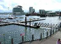 Cardiff Bay |
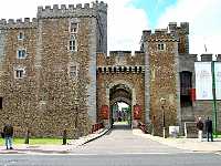 Cardiff Castle |
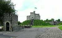 Cardiff Castle Keep |
The finest building in the dockland area, in my opinion, is the old Bute Dock Company building, but this was covered in scaffolding and shrouds so, with that and all the clutter of temporary railings and other paraphernalia for the eisteddfod the whole area didn't look very attractive and the whole lot was blighted by the scourge of modern society - litter. I made my way up to Cardiff Castle, the first checkpoint of the walk. The guidebook suggests that in order to claim to have completed the walk there are 41 checkpoints that should have been passed, with a few alternatives for route variants. These are generally at strategic points such as mountain tops but also in some other places to ensure that badly eroded routes are not followed. This allows some flexibility for detours and errors of navigation whilst ensuring that all the main aspects of the walk are fulfilled. The castle was just closing when I arrived at 5.15 pm, but the gates were still open allowing me to get a view of the old castle keep within the walls. The weather was rather blustery with spots of rain, though there were a few rays of sunshine from time to time, but the outlook was not too good with wet weather forecast for the weekend.
I joined the trail through Bute Park behind the castle, which provided a welcome relief from the bustle of the city traffic. After following the River Taff for a mile or so, it was time to head off towards Cardiff Youth Hostel, about three quarters of a mile off route. Last time I came this way, I had a bit of difficulty finding my way from the cycle track running along the east of the park onto the main road. This time it was even more difficult, as there was a lot of new development taking place and some of the access routes were blocked off. However, I did manage to find some steps leading through to the road not far from where I wanted to be and I made my way along to the hostel. The hostel was in the middle of refurbishment, so some of the facilities were out of action. It was not very busy and they were not serving evening meals so, after chatting for a while with the only other chap in my dormitory, I set off up the road in search of a pub.
The first place I came to was a Brewster's where I knew I would be able to get some food. I had been looking forward to some of the very good local real ales, having been reminded of them when I passed the Brains brewery earlier, on the way to the docks. Unfortunately, however, the Brains real ale had run out and there were only keg beers on offer. I settled for a pint of Murphys' and a cottage pie. This was pleasant enough but I decided to walk a little further in search of some real ale, and came to a pub called The Heath, though it was just as well that I had eaten in the Brewster's, as The Heath stopped serving food at 7 pm. The bar wasn't the best I have been in, with raised seating around a pool table and football on the TV so, after a pint of Brains' SA there, I moved next door into their lounge bar. This was quite busy and noisy but did have a more cosy layout and I was able to find a quiet corner in which I could relax.
The pub stands at the opposite corner of an enormous cemetery from the hostel, so I had walked around two sides of it on the way and completed the circuit as I walked back. It had just started to rain, but only a little, which was just as well, as I hadn't brought my waterproofs out with me. When I returned to my dormitory I found that a few more people had arrived and later, when I had gone to sleep, I was awakened by more late arrivals.
[Index of Walks]
[Previous]
[Top]
[Next]