The Pennine Way 1991

Author: George Tod
This walk is illustrated with photographs. Click on small photo to enlarge in situ, or click caption to enlarge into new window.
The Pennine Way 1991 |
||
|
Author: George TodThis walk is illustrated with photographs. Click on small photo to enlarge in situ, or click caption to enlarge into new window. |
|
| Part 3 - Howarth to Hawes | ||

[Index of Walks]
[Previous]
[Top]
[Next]
[Index of Walks]
[Previous]
[Top]
[Next]
Started at 9.20 a.m. and returned via the Bronte Way as there was not far to walk to Lothersdale. This time I found the better route at the back of the church and avoided the road. The Bronte falls were much more peaceful with hardly anyone about and, after a rest by the bridge, I reached the Pennine Way again by 11.10 a.m. The walk round Ponden is pleasant, but the wind was freshening from the NE. Ickornshaw Moor was bleak, with few redeeming features and, with a bitterly cold wind, it seems like it must be the low point of the Pennine Way. Eventually the cold forced the wearing of a thick jumper and, for the first time (and the last time), a change into trousers although my legs were not all that cold; it was more the rest of my body. Dropping down from Ickornshaw Moor brought more pleasant scenery and more shelter from the wind. At Ickornshaw I called for a pint at the Black Bull. They have hand pulled Whitbread and Tetleys and do bar meals etc.
![]()
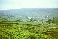 Ponden Reservoir |
 Lothersdale |
After a few hilly pastures and after lingering as much as the cool weather would allow, I arrived at the B&B at Lothersdale at 4.20 p.m. where I was greeted with a cup of tea, a large slice of quiche and a bun. The day's walk had been deceptively tiring; all the up and down over hilly pastures is as much as climbing a mountain, but without the reward of a good view.
The B&B has a very good drying room so, after a shower, I washed everything that needed washing. The thick socks that I washed in Haworth were still not dry after a night in Haworth's drying room and hanging all day from the back of my rucksack. I wandered around the village, which has a Post Office/Store and a pub. After sitting for a while in the park by the river I phoned home at 6 p.m. and then returned to the B&B where I found three other Pennine Way walkers who had just arrived; Tom and Jeanie, and Roger. We all ended up in the pub where the meals were all a bit expensive. The gammon I had was one of the cheapest at £4.60, but it was, at least, a huge piece and went down well with the Tetley's bitter.
The others had all set off on Saturday and were booking in as they went along. Tom was in the Merchant Navy and was told by Jeanie that they were doing the Pennine Way next time he came home on leave, so he had been breaking his boots in by walking around the ship! Roger was on his own and had a rather ambitious plan to finish in about 12 days, but started suffering from blisters on the first day. He began to realise that he could not achieve such a short time, so then planned to join the other two and extend the finish.
I had a room to myself with bunk beds and tea making facilities. There was also a patio with tables and chairs, which would have been very pleasant in warmer weather.
[Index of Walks]
[Previous]
[Top]
[Next]
Started at 9 a.m. with easy walking on a dull but pleasant day with less wind. After the climb to Pinhaw the walk goes over rolling pasture to Thornton, which I reached by 10.35 and, after stopping at the Post Office to write a card and buy drinks etc., I set off again at 10.50. There was more pasture then until the Leeds and Liverpool canal, which has an interesting double arched bridge. Into Gargrave there was more pasture and at this point the sun just started to break out. I met a lone, rather overweight, Pennine Way walker carrying camping gear. He was shuffling along in a very mechanical way, much as tramps tend to do - I presumed that this was because of the weight he was carrying. At the time I was not quite sure if I had come the wrong way, judging the direction from the position of the sun, but he pulled out his compass, quickly confirmed the direction and shuffled on his way again.
![]()
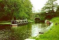 Leeds Liverpool Canal |
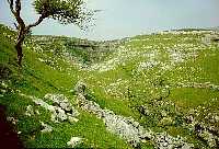
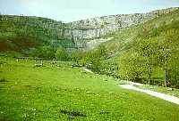 Malham Cove |
I stopped off in Gargrave to post off my first slide film and to have some lunch before proceeding along towards the Aire valley. The sun then came out fully, making it beautiful for walking by the river. The last stretch to Malham is on the hillside to the right of the river and gave fine views of the Cove. I arrived at 15.40 at the youth hostel, which was open from 13.00, but not for booking in. I dropped off my rucksack, changed into trainers and went for a walk around Janet's Foss, Gordale Scar and Malham Cove (about 4 miles) and happened to meet Mike Ward (who used to be my boss) and his family on the way. The weather turned out very fine and the scenery was fantastic, even though I had seen it many times before.
Dinner at the hostel was not the most inspiring, but O.K. -
soup, fish and chips and apple strudel. After dinner I met Tom
and Jeanie who told me that Roger had dropped out at Gargrave and
caught the bus back. Later I called in the Buck Inn which has a
good selection of hand pulled beers.
[Index of Walks]
[Previous]
[Top]
[Next]
![]()
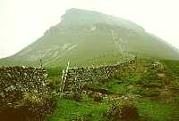 Penyghent from Gavel Rigg |
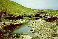
 Tarn Bar |
After a rather slow start waiting for the Y.H.A. card and packed lunch I got off at 9.15 to a cold, overcast start with a fresh north wind. The cove did not look so magnificent in drab weather. The walk was rather dreary past Malham Tarn with mist over the fells. However, the cloud was gradually rising and by the top of Fountains Fell it was only just hanging around the top and was not very thick. Coming down from Fountains Fell there should have been a fine view of Pen-y-ghent, but only a vague part of one end was visible, then a few patches of blue appeared in the sky and the full outline showed up. By the base of Pen-y-ghent it was a lot clearer and I had a rest before the steep climb to reach the summit at 2.10 p.m. with only 3 1/2 miles to Horton-in-Ribblesdale. The weather gradually improved to a beautifully sunny afternoon. On the descent from Pen-y-ghent I called at Hull Pot, which is about a quarter of a mile off route but well worth the detour as it is very impressive. In fairly dry weather no water reaches the pothole as it all disappears into the ground beforehand, but in wet weather there is a waterfall into the pot. I also walked down into Tarn Bar, which is like a miniature Malham Cove just off the route (although I think this was on private land). I reached Horton at 4.15 p.m. and met Mike and Edna who had to miss out Pen-y-ghent because Edna was not feeling well with a stomach upset.
My overnight accommodation at Stainforth Youth Hostel was, once again, about four miles off the route. There is a limited bus service, but I decided to walk instead, as I had enough time and preferred to do everything on foot if possible. I changed into trainers to help my feet and set off down the road, which was not very busy and had good verges to walk on. No bus passed me on the way, but I found out that they were at 15.40 and 17.35 from Horton, so I was just between them. The hostel was another old mansion and was very pleasant, with big rooms, which were not overcrowded. Dinner was soup, chicken and crumble, which were all very nicely cooked. Later I went to the pub in Stainforth with good Thwaites and met some of the other Pennine walkers.
The only bus in the morning was at 7.50, so it was a choice
between having breakfast or catching the bus. I decided on
breakfast.
[Index of Walks]
[Previous]
[Top]
[Next]
Started off at 9.05 a.m. with a lovely sunny start to the day and I decided to walk in trainers as far as Horton-in-Ribblesdale, so I put my boots, camera and map book into my rucksack as well as the full day's supply of food and water. After a short way along the road I saw what looked like a track across the fields, so I made my way along there. However, it turned out not to be a proper path and, after a mile or two, having had to climb a few walls, I made my way back down to the road again for the last mile and a half. The extra few pounds made the pack feel heavy and when I took it off in Horton-in-Ribblesdale and walked across the road to post a card, I felt as if I was floating across the road with my feet hardly touching the ground. It shows just how much you adjust to carrying a certain weight and how much difference a small change to that weight can make.
After a rest, I set off from Horton-in-Ribblesdale at 10.30 a.m. wearing my boots and continued on the Pennine Way again - it does seem a bit of a waste of effort doing these 8 mile return trips to youth hostels. It is not too bad if a pleasant off-road route can be found, but if there is no such route is readily available it becomes rather tedious and frustrating. Although in this case it is possible to use the bus, I feel it goes against the grain to use anything but foot power, even for off-route stretches. The alternative, in this case, would have been to stay in B&B accommodation in Horton-in-Ribblesdale or to use the Bunkhouse Barn which is about a mile from Horton-in-Ribblesdale, but which has no meals service. The weather clouded over but was not too bad and the first few miles out of Horton-in-Ribblesdale were not very interesting, as there was not much of a view from the track. After three and a half miles the route turned left and offered a fine view of Ingleborough with the cloud having just lifted from the top. Gradually the sun started to break through again and by 1.00 p.m. it was very pleasant, so I stopped for lunch at Ling Gill and stayed for a while to sunbathe. It was a very pleasant spot by the old packhorse bridge over the stream. Further down is a gorge, but access looked to be rather difficult so I didn't go down there.
![]()
 Ling Gill Bridge |
 Cam Houses |
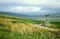
Apart from a very fresh north wind the weather was improving all the time as I started the ascent of Cam Fell with beautiful views of Ribble Head and the Three Peaks behind, and Cam Houses and Upper Wharfedale in front. Along West Cam Road I went a little way down the side of the valley to get a better view and take some photographs, and eventually arrived at Hawes youth hostel at 6 p.m. I discovered that the ones who had caught the bus in the morning and set off from Horton-in-Ribblesdale at 8 a.m. had missed the best of the weather and had walked much of the route in mist. By setting off later and not taking the bus, I had managed to do much of my walking in fine weather.
The hostel at Hawes was a modern purpose built one, with a very friendly warden and good facilities. For dinner I had soup, fish pie and apricot crumble. My feet were feeling a bit tender at the end of the day but this could be because much of the walking has been on hard tracks and roadways. The backs of my legs were feeling rather sore having caught the sun for most of the afternoon.
After dinner I went into Hawes for a drink and met up with several of the other Pennine Way walkers. There were a number of pubs to choose from, as Hawes is a busy market town.
[Index of Walks]
[Previous]
[Top]
[Next]