Pembrokeshire Coast Path 2001

Author: George Tod
This walk is illustrated with photographs. Click on small photo to enlarge in situ, or click caption to enlarge into new window.
Pembrokeshire Coast Path 2001 |
||
|
Author: George TodThis walk is illustrated with photographs. Click on small photo to enlarge in situ, or click caption to enlarge into new window. |
|
| Part 1 - Preparation and First Day - St Dogmaels to Newport | ||

[Index of Walks]
[Previous]
[Top]
[Next]
My previous year's walk of the Cambrian Way left me thinking that I would be hard pressed to find anything finer. I toyed with the idea of Offa's Dyke as I had done several times in the past but considered that too much of the walk was at a low level and lacked the appeal of mountain top walking. Having moved the previous year to North Wales it seemed more sensible to do another walk in Wales and I was all set to do a repeat of the Cambrian Way with possibly a few variations. However, the dreaded foot and mouth disease struck Britain and seemed to rule out the chance of any walk in my preferred month of June. It was a great relief when areas such as Snowdonia started to open up to walkers, but fresh outbreaks of the disease in the Brecon Beacons added a great deal of uncertainty to the possibility of any walk passing through that area. I, therefore, decided to plan a walk in September and chose an area that had been free of infection throughout in the hope that there would be a far less risk of having to cancel or bypass certain parts. For this reason, I decided on the Pembrokeshire Coast Path, which had been fully reopened in the summer.
Having considered this walk on a number of occasions in the past, I still had some reservations as to whether two weeks of continual coastal scenery would be too much of the same thing and would lack the variety that makes for a good long distance walk. However, it was better to plan a walk like this than risk having to cancel a walk in other parts, so I decided to reserve my judgement until the end.
The Pembrokeshire Coast Path is a walk of from 186 miles to 200 miles depending on route variants due to tides and firing range activities as well as a number of optional detours around headlands. As its name suggests, it follows the coast of Pembrokeshire from the northern county boundery at St Dogmaels to the southern boundary at Amroth and follows the cliff tops for most of the way. A large proportion of the route is within the Pembrokeshire Coast National Park, the exceptions being the urban areas around Fishguard and Milford Haven. Much of this coast is remote and not easily accessible by road and, therefore, has remained largely unspoiled, with abundant wildlife and flora. It was opened as a National Trail in 1970 and the route is published in National Trail Guide No. 7 by the Ordnance Survey (ISBN 1-85410-459-4) as well as in other publications.
[Index of Walks]
[Previous]
[Top]
>[Next]
As always, the planning of accommodation was a difficult process. It was made more difficult this time because many Youth Hostels had been closed for some time because of the foot and mouth outbreak and it was not, at first, certain whether they would revert to their normal scheduled opening dates. Generally, the key to planning a walk is locating a good accommodation guide aimed specifically at the walk rather than more general accommodation guides for the region. Surprisingly, the National Trail Guide only made reference to a Tourist Board telephone number and they were only able to supply brochures for Pembrokeshire with very little suitable accommodation near the path. After trawling around on the Internet I managed to find a list of National Park publications amongst which was a very good accommodation guide for the route. Armed with this and updated information on the Youth Hostels I could then start booking accommodation for the walk.
One advantage about walking in September is that the hostels are not booked up by school parties, but it was surprising that some hostels had already closed in early September and had reverted to the 'Rent a Hostel' scheme for block bookings. The other problem was that there are two places on this walk where a crossing is only possible at low tide, and other sections of the path which can be closed by military firing range activities, all of which may require detours if the timing is not right. I located some tide-tables on the Internet to help with planning and decided to cross the firing ranges at a weekend when they were more likely to be open to the public. The only section that was then giving me problems was a long stretch from Pembroke to Castlemartin, where there was no accommodation listed. There was a pub marked on the map at Angle, so I found their number on the Internet and gave them a call. They did not do bed and breakfast but put me onto a couple across the road that did. This enabled me to complete my bookings with no section of more than about 17 or 18 miles. One advantage of planning a walk around peninsulas and headlands is that it is sometimes possible to approach accommodation from two different directions, and I took advantage of this to even out some of the daily walking distances.
I had not done as much walking as I would have liked over the past year due to a very busy schedule of maintenance work on the hotel that we had taken on, but I was still quite fit because of all the work I had been doing. I had managed to fit in a few walks along the way including a climb of Ben Nevis. I surprised myself by reaching the summit in just over 2 hours 10 minutes, whereas the same climb had taken me 4 hours in my youth. It just goes to show that age is no barrier to walking provided you are in good health and do regular exercise.
[Index of Walks]
[Previous]
[Top]
[Next]
My daughter Jen kindly offered to drive me down to the start at St Dogmaels. The plan was to drive to Amroth first to see where we should meet at the finish, but the rather slow progress along the winding roads through Wales made us change our plans and go straight to St Dogmaels. In any case, there appeared to be two good landmarks on the map near the finish, Amroth Castle and a pub. She dropped me off by St Dogmaels Abbey, which was actually half a mile before the official start near the landing stage. It was only a little after 2 p.m. and the weather was dull and overcast, but at least it was better than the heavy rain we had left behind in the morning. My first night's stop was at Poppit Sands Youth Hostel, only two miles from the start, so I made my way steadily up there, not bothering to change into my walking boots as it was all road walking.
![]()
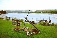 Start at St Dogmaels Landing Stage |
Poppit Sands Youth Hostel commands a fine position on the headland overlooking Cardigan Bay and Cardigan Island. It was only a pity that the weather was so dismal to spoil the view. It was still rather early for checking in, so I found a sheltered spot to sit overlooking the bay until the drizzly rain forced me take shelter by the hostel. Soon the volunteer warden and her husband arrived and I was able to check in. There were several other hostellers there - a French couple, an Italian couple, three teenage girls and a retired teaching couple. The hostel is self-catering only so, after a while, I set off down the hill towards the Webley Hotel that I had passed on the way, to get something to eat. I had not gone far down the road before it started to rain, so I quickly headed back for my waterproof jacket, which was just as well as I would have been soaked by the time I got there. There was a very friendly atmosphere in the bar and I chatted to the landlord and some of the locals as I had a few pints and home-made mousaka. One of the locals was a keen historian and was full of praise for some of the newcomers to St Dogmaels as they had done a lot of work to obtain grants for restoration work on the Abbey and to open up a museum. This was very pleasing to hear because one often finds resentment of newcomers in remote areas.
It was getting dark by 8.30 p.m., which was one of the disadvantages of walking in September, so I made my way back to the hostel whilst there was still enough light to see the way. After spending a while in the hostel lounge chatting to some of the other hostellers, I decided on an early night ready for the first full days' walking.
[Index of Walks]
[Previous]
[Top]
[Next]
I got up at about 8 a.m. and bought some muesli, milk, bread and marmalade from the hostel shop for breakfast. The weather was much brighter with quite a bit of blue sky, although there was a fresh NW wind. It took me a while to pack my things as I had not yet worked out a system for where to pack everything in my new rucksack, which had one less pocket than my old one. It makes quite a difference if things can be packed in a sensible way and avoids having to empty out the whole contents in order to find something.
At 9.30 a.m. I finally set off up the road for a mile or so, which led to the footpath around Cemaes Head. The view across the bay was much better in the brighter weather and, after rounding Cemaes Head the view opened up down the coast towards Dinas Head and Strumble Head past Goodwick, two day's walk away. There were some very spectacular views along the cliffs, which are the highest ones of the whole walk.
![]()
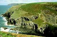
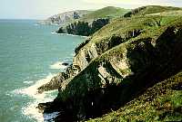 North from Foel Hendre |
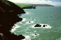 South from Foel Hendre |
 SW across Ceibwr Bay |
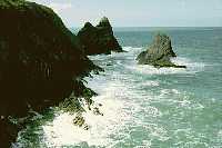
I stopped for lunch north of Ceibwr Bay with lovely views of the sea crashing over the rocks below and of the coast stretching out to the south-west. The clouds that were forming earlier over the high ground were getting fewer with lots of sunshine but still a fresh wind. There are some splendid coastal features along this stretch of the path with rocky outcrops and inlets. At the Witch's Cauldron, which is a pool created by a collapsing sea cave, there was a grey seal swimming in the pool and another one climbing out of the sea onto the rocks nearby.
![]()
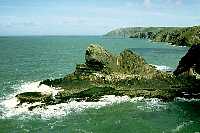 Gareg Wylan |
 The Witches Cauldron |
 Newport Bay |
As I had plenty of time and the wind had eased somewhat, I stopped for a while to sunbathe. So far along the path I had only met one couple and two individual walkers, all just out for the day, so it was very peaceful and the coast was almost completely unspoiled.
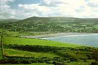
This part of the route has a lot of ups and downs, some of them quite steep, making it one of the most strenuous sections of the walk. This is not the best thing for the first day but, as it was less than 14 miles, there was plenty of time to rest and take it steadily. The cliff scenery further along was less interesting, but there were some fine views looking back and a few spectacular sheer drops. Rounding Morfa Head, more of Newport Bay came into view and further along the scenery changed quite dramatically from steep cliffs to a gentle scene overlooking Newport Sands with Newport itself up on the hillside beyond.
The large area of mud flats is home to a great number of birds, including a heron, which was near the bridge. For the latter part of the day's walk I met up with a retired chap from Lichfield, who was walking from St Dogmaels to Newport, where he and his wife were camping. He was a lifelong walker and member of the Long Distance Walkers' Association, so we had an interesting chat on the way until we parted company in Newport.
I easily found the guest-house where I was staying and, after a shower and pot of tea, decided to take a stroll along the coastal path to Parrog to enable me to take a short cut the next morning. It was a beautiful evening, the wind having dropped, and I sat for a while overlooking the bay before heading back into town for something to eat. There were a number of pubs to choose from and I stopped at one for a rib eye steak and a few pints of Cousin Jack bitter before going back for an early night.
[Index of Walks]
[Previous]
[Top]
[Next]