Dales and Lakeland Walk 2008

Author: George Tod
This walk is illustrated with photographs. Click on small photo to enlarge in situ, or click caption to enlarge into new window.
Dales and Lakeland Walk 2008 |
||
|
Author: George TodThis walk is illustrated with photographs. Click on small photo to enlarge in situ, or click caption to enlarge into new window. |
|
| Part 3 - Kettlewell to Dent | ||

[Index of Walks]
[Previous]
[Top]
[Next]
[Index of Walks]
[Previous]
[Top]
[Next]
After a good night's sleep, I awoke to find that it was wet outside but the rain was not heavy. Breakfast started at 07.45 and most people were down by then, though nobody, including myself, was in a hurry to get started in the drab weather conditions. The forecast posted in the hostel was not as bad as it could have been, promising light rain and moderate wind and temperatures. I spent a while chatting to the chap who was doing the Nuttalls and to a Norwegian woman who sat with us. She had visited nearly everywhere in the UK, spending long holidays here every year.
Eventually, I got everything packed and was ready for off at 09.15. I was surprised that nobody at the hostel seemed to be walking the Dales Way, but then Grassington tends to be the main stopping point at the end of the first day and Kettlewell is only 5½ miles further on, so not enough for a day's walk. One of the chaps from my dormitory had been outside and said it was hardly raining at all, so I set off outside without wearing my waterproofs only to be met by a fairly heavy downpour, so I did a quick U-turn to the hostel to put my waterproofs on. When I got outside again, it was only drizzling. It was obviously going to be that sort of day where it was best just to leave them on, as there was a fair chance that it would soon start raining again. There were a few bright spells when a weak sun tried to break through, but the rain was never far away, though, at the moment, not heavy.
The start of the walk was up over the fell-side, with the path running at an angle, making it just a steady climb with good views across the dale despite the drab conditions. The higher fells, however, were covered in cloud above about 1,500 to 2,000 ft. The climb became gentler near the rounded top of the ridge with views of the valley bottom now hidden by the hillside. Over the top, the views over Littondale opened up with Arncliffe down below. This is the village that was used as the setting for the soap opera Emmerdale when it first started many years ago, with the Falcon Inn becoming the Woolpack of the soap opera. After some years, the television people got fed up of the slow drive from Leeds and moved to the village of Esholt, only a few miles from where I used to live, using the Commercial, a pub I often visited, as the next Woolpack. The atmosphere at the Commercial was completely ruined by the influx of coach parties once people got to know about its location, though I am sure that the landlord was laughing all the way to the bank. Later they decided on having a permanent set built in the grounds of Harewood House to save all the trouble of closing off streets and changing signposts etc.
There was an easy path down to the wood, where a stile over the wall led to a steep limestone scar. I couldn't see a route down at first, so went back over the stile to see if there was a different way down. However, it was obvious that the route was intended to go down the scar, so I returned to find the best way. I scrambled very cautiously down the wet limestone, which can be treacherously slippery when polished smooth by the passage of many boots. After a short while I was past the steepest part, but still needed to take care down the rest of the path.
From Arncliffe, the path followed the river for a few miles, at first some distance away on the flat valley floor, but later running alongside. When I rejoined the River Skirfare, it was completely dry. This is not uncommon in limestone areas, where the water sinks through fissures in the rock into underground streams. It is only when there is a reasonable volume of water flowing that any of it runs along the surface, when there is too much water for it all to leak away. What is quite strange is that little pools of water left behind in hollows in the limestone riverbed were a pinkish red in colour. I don't know whether this is because of some chemical reaction or living organisms that caused this effect.
The valley bottom walk was not very inspiring, but was easy going for most of the way, except for the stretch by the river that was stony, with a lot of tree roots. There were a few meadows full of buttercups, daisies, clover, cowslips and many other wild flowers to make the walk better and, on a better day, there would be more to see up the fell-sides, but this was not the case today. I stopped for a rest and some food at 11.45 near Litton, but didn't stop for long as it started raining again. At Nether Hesleden, my route went up the hillside towards Plover Hill. I had intended to take a track marked on the map, but there was a sign saying 'No Public Access', so I had to take the path further south leading me a longer way round. Once I reached the minor road from Malham to Halton Gill, I was able to double back to where the track emerged onto the road. At this end it was open country, with nothing to indicate that the track was private, though access land only started at the other side of the wall from the track.
All of Plover Hill above the level of the road is access land, so I could have taken a route up there from this point, but I thought it might be rough going and my planned route skirted round to the northern side of the hill on footpaths and tracks before ascending from directly north of the summit. This was a considerably longer route, but with the low cloud, would offer at least some views for most of the way. There were one or two signs of improvement in the weather, so it was just possible that the cloud would lift before I headed for the summit. As I made my way round the end of the fell opposite Halton Gill, I was rewarded with a patch of sunshine that lit up the valley. Not just one but several patches of sunshine came by as I took another rest overlooking the lovely view across the dale, though there were still a lot of very black looking clouds hovering over the fells.
![]()
 Halton Gill |
Round the northern side of Plover Hill, the track and footpath marked on the map became less clear on the ground, and I decided just to head for the top of the ridge instead. This wasn't the easiest access, as it was over rough moorland with some steep climbing in places, but I eventually reached the ridge and the wall running towards the top of the hill. Wherever there is a wall along a ridge, there is generally a path beside it, and this was no exception, so there was no mistaking the route, which was just as well, as I soon entered the cloud and was surrounded by mist. I reached a point that appeared to be the summit, but as the hill is very flat-topped, I had to check with my GPS that I was actually in the right place.
By now it was raining steadily and getting heavier all the time, and up on the exposed hilltop, the wind was very strong and was lashing the rain into my face. To get to Pen-y-ghent, it was just a matter of turning left and following the wall all the way. It was amazing just how flat-topped much of the ridge was. It was starting to get boggy, but, because of the long dry spell of weather previously, most of the peat was still quite firm, which made things a lot easier. After quite a while, a steady climb upwards indicated that I must have reached Pen-y-ghent, and soon the summit came into view through the mist. The wind and rain were even worse here, so I made my way over and down the other side as quickly as possible. On the way down the steep, stepped path, I met a few Pennine Way walkers coming towards me, on their way to Horton-in-Ribblesdale like I was, but by a different route.
At Brackenbottom, after the steep climb down, there was much more shelter from the wind, and the rain wasn't as heavy, making life a bit less unpleasant. The rest of the way was along an easy path and then minor roads into Horton-in-Ribblesdale, bringing me out right by the church and the Golden Lion, where I was staying. It was 16.55 when I arrived and met three lads who were trying to get into the pub via the visitors' entrance, as the main entrance was closed. They had been shown the way in earlier in the day, but the door they had gone through before warned that opening it would set off the intruder alarm. Soon afterwards, a lady arrived to open up, so I was able to check in to the bunkroom.
When I stayed here last year, the bunkroom had been taken over by a group, so I was given the exclusive use of a static caravan instead, which was great, as I had all the facilities to myself. The bunkroom, however, seemed to have been designed by someone who had never had to use one. The bunks were three high, with nowhere for storing things and very little spare floor space. There was not even a single seat to sit on for taking off and putting on shoes or boots, and perching on the edge of the bunk was quite uncomfortable, with a wooden bar running along the side. The adjoining toilet and shower room was fine, except for the same lack of any seating or anywhere to put clothes whilst in the shower cubicles. I had a nice, long, hot shower to warm me up which made me feel a lot better. However, there was no drying room and nowhere else to dry out wet boots or clothes.
When I thought about it, I realised that the main use of the bunkroom is for people who are doing the Yorkshire Three Peaks Challenge. They normally arrive by car one evening, walk the next day, then, either drive back home, or stay another night and return home the next day. If all their things are wet, they are not particularly worried, as they can just bundle them in the car and get them dry at home. For other walkers, however, it is a different situation, and presents a few problems. Several other people rolled up to use the bunkroom, some of them Pennine Way walkers, and one of them persuaded the landlady to put on the heating, which made things a lot better, as there were now a couple of radiators on which to dry things.
I went into the bar for a drink. It was a complete contrast from last time I stayed during the BT Three Peaks Challenge. It was very difficult then to even get into the bar because of the great crush of bodies, but now I was the only one in there. The wood fire had just been lit, so I had a pint of Timothy Taylor's Landlord bitter and sat by the fire for a bit of warmth. The bar lady was telling me that last weekend, the time of another Three Peaks Challenge, they served 150 meals. A number of Pennine Way walkers joined me in the bar, one of whom had done the walk twelve times already and still kept coming back to do it again. He said he was just doing the same as many other people who always go back to the same place for their holidays. He knew the route so well that he didn't need to use maps, he stayed mostly in the same places that he knew well, and he knew that he enjoyed the walk, so what was the point of doing anything else. Unfortunately, I am not so easily satisfied, as I am always trying to find something different, spending a lot of time trying to think of which walk to do each year, and going through all the difficulties of working out where to stay each time.
[Index of Walks]
[Previous]
[Top]
[Next]
At 06.00 an alarm clock went off - it was the three lads who were embarking on the Three Peaks Challenge. They got themselves dressed and then went off with some cooking pans to make their breakfast, returning some time later to get their things ready. It was 07.45 before they left still talking about sorting out their packed lunch. It might have been a bit more considerate to other people if they had done more of their preparation last night and not had to get up so early. It didn't bother me too much, as by that time I am generally half awake anyway, but there were others who didn't like being disturbed that early.
The only others in the dormitory, apart from myself, were a couple who were doing the Pennine Way and a chap on his own who was also doing the Pennine Way, but as part of a longer walk to Scotland and the West Highland Way. I hadn't realised before that it was a mixed dormitory, but wondered what was supposed to happen to people's modesty when they used the clear glass-fronted shower cubicles - just another thing that hadn't been thought through in the design of the bunkhouse. The couple had decided to pack in their walk, as the lady was having problems with her hip and, with that and the bad weather over the past couple of days, she had had enough. The chap had done the walk before, so wasn't too worried about not finishing it this time.
The weather was certainly a big improvement on yesterday's, with broken cloud and patches of sunshine, but with quite a fresh wind. There was still some cloud covering the tops of the fells, but with a bit of luck, that could clear later. Breakfast was not until 08.30 and there were about a dozen people in there, some of them from the B&B accommodation.
Most of my things were fairly dry, only my boots remaining rather damp. They had done quite well in keeping out most of the water but, after prolonged walking through wet grass and puddles, water generally starts to soak through the leather. I had developed a small blister on one of my heels, probably caused by the rubbing from the partially disintegrated boot lining. The gaffer tape that I tried to cover this up with had come adrift with the wet, so I removed it, as there was no point in leaving it there where it would probably do more harm than good. I burst the blister with a snip from a small pair of scissors, got the rest of my things ready, and was off at 09.30, calling at the Post Office to buy a few things for lunch.
As I walked along the road through the village, I passed by the campsite, where there was a large group of mainly Asian youths, presumably on some sort of field trip. Before I had even left the village, a fairly heavy shower of rain made me stop to put on my waterproof jacket. The rain soon stopped, but with the strong, cool wind and the prospect of more showers, I left my jacket on. The cloud was already clearing from Pen-y-ghent, but there was still some over Ingleborough and Whernside, where I was heading.
![]()
 Pen-y-ghent from Station |
 Pen-y-ghent from Ingleborough |
The ascent of Ingleborough from the railway station is quite gentle for the first couple of miles, leading up above a large area of limestone pavement. There was a lot of cotton grass about, most of which was fairly well spread out, but one area below the limestone pavement was so densely packed with it that it showed up as a bright white area from a distance. As I climbed up further, patches of sunshine came and went and the wind got stronger and cooler. I was feeling a lot fresher this morning than yesterday, so even when the ascent got steeper, it didn't present any difficulty. A lone walker was ahead of me all the way, and I finally caught up with him just before the final ascent onto the summit plateau. He was just out for a day's walk over Ingleborough and Whernside, and we walked to the summit together. The final ascent onto the plateau is quite steep, so took a bit of effort, but we were soon up and heading along the stony, gently sloping ground towards the summit itself. As expected, the wind was quite ferocious up there, but the shelter gave some very welcome respite. A couple with a toddler were already there, having walked up from Ingleton, with father carrying the little girl on his back.
Soon after we got to the summit, the cloud, which had been hovering around the top, dropped a little so we were now in the mist without a view. I had a drink and ate some of my lunch, waiting a while in the vain hope that the mist would clear, but when it showed no signs of improving, we all set off on our different ways. My initial plan had been to follow the normal Three Peaks route to Whernside, though I had a mind to walk over Simon Fell on the way. There was no footpath shown on my map, but there seemed to be a reasonable one on the ground, so I decided to take that option so that I could stay high up for longer. Once off Ingleborough's summit, I was back below the cloud, which was swirling past at high speed just overhead in the strong wind.
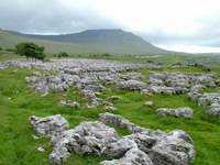
As I made my way along the easy walk to the summit of Simon Fell, I had good views of the limestone pavements across the valley and of the Ribblehead Viaduct, until the flat top of the fell cut them off from sight. The best way to walk for the rest of the way was along the edge, overlooking Ribbledale, where the views were much better, even though there was a much more forceful wind. Whernside was still in the cloud, but this gradually lifted as I made my way along, with an ever-improving view of the viaduct, as I got nearer. The route down from Simon Fell was not very well defined, but was not too difficult, leading towards the Three Peaks route. Near the bottom, I took a lunch break, sheltering from the wind by the wall. From there I crossed through a nature reserve centred on an interesting area of limestone pavement, with deep fissures between the rocks. After scrambling down a few limestone shelves, I was back on the main route, near to where it crosses the road by the Old Hill Inn at Chapel-le-Dale.
![]()
 Limestone Pavements |
 Ingleborough |
The ascent of Whernside from this direction, which is the opposite way from that normally walked in the Three Peaks walk, is very steep, after a gentle preamble to the foot of the fell. A lot of work has been done on pathway repairs because of the large number of people walking and running the route, so there are steps up the steeper parts and a stone pathway over much of the rest, especially on the ascents and descents, which is where most of the wear and erosion occurs. As I climbed up, the wind, which had never gone away, got stronger and cooler, and when I reached the ridge it was quite ferocious, just as it had been on Ingleborough.
![]()
 Ribblehead Viaduct from Whernside |
 Ingleborough from Whernside |
I started meeting a number of Three-Peaks walkers coming the other way, as this was roughly the halfway point of the walk. One or two girls were hobbling along in some discomfort even at this stage, so it didn't bode well for their chances of completing the walk. I then met the three lads from the bunkhouse, who seemed quite pleased with their progress so far, even though they didn't know the names of any of the peaks. One of them asked me if I had just climbed 'that one over there', pointing to Ingleborough. He then told that they had climbed over 'that one' first, pointing to Pen-y-ghent, and then came round the back of 'this one here' (Whernside), and had to climb 'that other one there next' (Ingleborough). What did it matter, though, they were enjoying themselves and would, no doubt, get a real sense of achievement once they had completed the challenge.
I stopped for a while at the summit shelter to get some respite from the wind, but didn't stay long, as it was quite cool and I still needed to make some progress. I had not had an early start, and I had also added more distance and time by taking the route over Simon Fell. There were some lovely views from the summit ridge now that the cloud had lifted, with miles and miles of hills and mountains as far as the eye could see in all directions. I had been able to see the views to the east earlier, but now there were views into Dentdale and across to the Howgill Fells and the Lake District.
On my way to Dent I needed to join the Craven Way, an old drovers' road from Ribblehead to Dentdale. On the map it looked as if there was a path more or less linking the path that dropped down from the northeastern end of Whernside, to the Craven Way, thus avoiding two sides of a triangle and a few hundred feet of descent, which would have to be regained. I could see no sign of a path, only rough, heather moorland, which looked like hard going, so I continued downwards, managing to avoid some of the wasted effort by following the wall instead of the Ribblehead path part of the way down.
The Craven Way is a lovely grassy track for most of the way and, although I still had to gain some lost height, I was able to make good progress. The route down into Dentdale was more stony and rutted, but didn't slow me down too much. Had it not been for the very dark clouds over Dentdale, the views would have been very good. At the bottom of the fell, I joined up with the Dales Way for a pleasant riverside walk all the way to Dent, which I reached at 18.10. Just as I was coming into the village, I was caught in a heavy shower for the last five minutes of the walk. Apart from a shower at the start of the day and a shower at the end, the rain had managed to keep off for the rest of the day, though the cold wind had not let up the whole time, except where I was sheltered by the hillsides in places. All in all, it had been a very good day, with some marvellous views and fine walking even if it had been cold and windy.
My accommodation for the night was in the Sun Inn, so I was able to have a pint when I checked in, before going up to my room, having a shower, and getting changed. My mobile phone had no reception again, except for emergency calls, but I was able to use the payphone in the pub. The Sun Inn is a traditional old Dales pub built around the 15th or 16th century. As is usual with this type of building though, the floors are uneven and the floorboards creaky. My room was not en-suite, but this was reflected in the price, so it didn't bother me. In many places, rural pubs are having a very hard time, with many having to close through lack of trade, but here they had a thriving bar trade, much of it from locals. No doubt there have been times in the past when the trade has been even better, but they certainly seemed to have enough to remain viable. The atmosphere was very convivial, with everyone joining in on the various topics of conversation that were going on around - just what is expected of a village pub, but something that is often lost these days.
After my shower, and watching the weather forecast, which gave sunshine for most of the day tomorrow, particularly in the afternoon, I returned to the bar for a couple more pints and a bar meal. I had an enormous, homemade Cumberland sausage (I think it said it was a pound in weight) and some Titanic Lifeboat bitter, which was darker than normal, with a bit of the taste of a stout, and tasted very good. These days, with lots of small breweries emerging everywhere, there are a whole host of excellent beers around that are seldom heard of outside their local area. The weather had already brightened up, but it had been a rather tiring day, so I was ready for bed.
[Index of Walks]
[Previous]
[Top]
[Next]