Part Cambrian Way 2016

Author: George Tod
This walk is illustrated with photographs. Click on small photo to enlarge in situ, or click caption to enlarge into new window.
Part Cambrian Way 2016 |
||
|
Author: George TodThis walk is illustrated with photographs. Click on small photo to enlarge in situ, or click caption to enlarge into new window. |
|
| Part 7 - Days 11 & 12 Pontrhydfendigaid to Cemmaes | ||

[Index of Walks]
[Previous]
[Top]
[Next]
[Index of Walks]
[Previous]
[Top]
[Next]
The GPS mileage figure includes small detours, meandering around, and errors in route finding. In general this is about 5% to 15% greater than the mileage calculated from a map depending upon the type of terrain, but in some cases is considerably more.
As expected, the things I had washed were still very wet. The forecast was for heavy showers but possibly some bright spells, so I could but hope, though had to be prepared for the worst. After my breakfast, I went to pay the bill for my meal and phone call and someone in front of me was paying their whole hotel bill by debit card. They were being charged a surcharge for paying by card. It was only about 1%, and less than the surcharge for paying by credit card, but it is very unusual in the modern day to be charged for debit card payments at all. The charges for processing debit card transactions used to be just a small fixed price regardless of the amount being paid, and most businesses would absorb this as part of the running costs. However, the receptionist was saying that since earlier this year, the charges were now based on a percentage of the transaction, so they were adding a surcharge to cover this. This just tends to highlight the attitudes that remain in an old, family run business in rural Wales, where the feeling is that every penny of the bill should go to them and any other overheads should be paid by the customer, whereas in other places businesses are generally willing to absorb these relatively small charges themselves to avoid loss of goodwill of their customers. I later checked online and found that in 2015 the charges that banks could make were capped at 0.2% plus 1p on debit cards. However, the companies who provide the card machine services generally put a large markup on these, especially to small businesses. When we ran our hotel, however, we absorbed card processing costs, even including corporate AMEX cards, with an extortionate 5% fee or more.
When it came to my bill, there was no problem as I had paid for the room online without incurring a surcharge and I paid for the meal and phone call by cash.
I set off down the busy A44 road at 9.15, calling at the shop in the petrol station not far away to buy a Cornish pasty and an oat bar for my lunch. In the shop I met a lady who had been with the large party eating in the restaurant, and she told me they were a group of RSPB members on a trip from North Wales. She was from Llandudno and the others were from various places along the coast between there and Prestatyn, so they were not far from where I live. I should have bought some more AA batteries for my GPS, as I was now on my last pair and wasn't sure whether they would last to the end of the walk. Having a chat with the lady made me forget and it was not until I got some way along the road that I remembered, but decided not to turn back hoping that I may be able to pick some up elsewhere.
In the centre of Ponterwyd the route leaves the A44 and soon takes a footpath which joins the less busy B4343 before rejoining the A44 not far from the Dyffryn Castell Hotel where the ascent of Plynlimon begins. There was some fast moving traffic on these roads, but there were verges to walk on in places, though I was stil glad when I was able to get away from them altogether. The Dyffryn Castell Hotel closed several years ago and was eventually sold to someone who started major renovation work on it, but this came to a halt and it has been looking more and more derelict ever since. It is still in need of a new buyer, with 'For Sale' signs up. It is a pity that a place like this in what seems like an ideal location cannot find a buyer, but such is the fate of many such rural pubs and hotels with insufficient local trade to help them through the winter months. In this area, most people are heading towards the coast so would not generally be looking for accommodation.
I started up the hillside with mist around making for poor visibility of about 30 yards. My feet very quickly started to get wet from walking through the grass and then the wild bilberries further up where there was only a faint path through. Along the side of the forest, the path is shown going into the forest and then back out again, but the forest is now more or less impenetrable, so the path just runs along the other side of the fence instead of entering it and most people seem to not bother to even cross over the fence but stay on the right hand side. This means climbing over a fence, but this is not very high and, as this is now being Access Land, there is no problem of right of way. Further up there is a wide gravel track which was even wider and more extensive at one time. It was being used by someone practising his rally driving until complaints to the Council resulted in him having to let the grass grow back over a lot of it, though some of the track still remains. I have used this track in the past, but this time followed the intended route which goes straight up the hillside to the top corner of the forest rather than cutting off the corner as the track does. This is actually better as it is on a softer surface and joins a grassy path along the ridge with views on either side, though today there were only misty views for quite a short distance.
As I was walking along the ridge, I got a call from my wife, so I must now have managed pick up a signal that was absent lower down. It was getting cold and wet further up as there was a cold wind at the top of the ridge so I was getting more and more chilly despite the effort of the uphill climb. Eventually, the summit loomed into sight through the mist and I was able to hide from the wind in the shelter. By this time I was starting to shiver with the cold, so I quickly put on my fleece underneath my waterproof jacket to try to get warm. In the first week or so of the walk I kept looking at all the things I had with me for cold weather: a fleece, a warm jumper, a hat and gloves, which all added to the weight of my pack when the main problem I had was trying to keep cool. For the first time now I really needed something warm, though it never got to the point of wearing the hat and gloves not the jumper.
I only stayed at the summit for long enough to have some lunch, as it was pretty cold, wet and miserable, so I pressed on, trying to keep warm and make progress so I could descend from the mountains to where it might not be so cold and wet. I didn't put on my waterproof trousers because of the nuisance of having to take off my boots to do so, and I was still walking in shorts that were now very wet. Once I got moving again I managed to keep warm, but only just. Further along the mist lifted and there were some distant views but it was still dismal. Eventually, I passed the source of the River Severn where the route then goes over rough ground before descending the mountain towards Bugeilyn Lake. My GPS was quite useful in showing the way, but the exact route isn't important so long as it is in the right direction which was easy to see now that there was no mist. The only thing to look out for is a marker post where there is a crossing place over the stream. I was never quite sure about the importance of this, as I had sometimes crossed elsewhere without a problem. However, the stream actually runs in an underground pipe to emerge by the marker post, so anywhere to the east of this is easy to cross with only some small streams of surface water, whereas there is much more water around to the west. It was still quite boggy with a lot of reeds, so I took the shortest route up to the track that leads round the lake rather than trying to cut the corner off.
Once on the track, it was easy going but I was getting tired having had very little rest since I started out this morning. It is always difficult in the rain when out in the wilds as it is never comfortable to sit for long anywhere. There was still not much shelter around, but by the ruins of the old farmhouse was a large barn with doors that were not locked, so I was able to go in there to have a rest sheltering from the wind and rain, though there was still nowhere to sit. I was able to finish off what I had left of my lunch as well as having a drink, though in the cold and rain there is no need for a lot to drink.
A little further on, the route now joins Glyndwr's Way, which is quite well waymarked, so it is easy to follow and the only thing to watch out for is the path down into Dylife from the ridge a few miles further on. There was no let up in the rain and I arrived at The Star at about 6.00 dripping wet. The entrance was geared up for wet walkers with a box of screwed up newspapers for putting into wet boots, so I took off my wet things and went through to have a cup of tea and some cake. This used to be the Star Inn, but the elderly couple who owned it retired and Louise who took it over a few years ago spent a lot of money refurbishing it. I hardly recognised the place when I went in though what used to be the lower part of the bar, where there were now cosy leather armchairs instead of tables and chairs. The upper end of the room is still used as a bar and dining area, but is now just for guests of the B&B and not for the general public.
The idea had been to offer workshops and therapy treatments in this remote retreat from the pressures of modern life as well as accommodation for walkers and other visitors. It was still run as a pub initially, but the local trade gradually declined making it no longer worthwhile to run it as such, so application was made for change of use to a B&B. This was resisted initially, as it was the only pub in the area, but it was pointed out that there was virtually no bar trade by this time, so the change was granted. Unfortunately, the treatment and therapy side of the business didn't take off in the way that was hoped, so trade tends to be just the few walkers and other tourists who are passing and they tend to stay for only one night. Reluctantly, Louise has decided to put it back on the market, having had her dreams shattered, and having poured a lot of money into the venture that she will not get back. It was probably something that may have taken off in a different place, but wasn't working here.
There was no mobile reception nearby, but there was still a phone box not far down the road, so I was going to go down there to call home before dinner, but Louise, kindly offered me the use of her phone to make the call.
The establishment is eco-friendly and there is a discount for those who are not using motorised transport. Most of the food including the bread is homemade, and there is a pescatarian menu, which is vegetarian plus fish. This means that there are more things to please those who are not vegetarians like myself. The sleeping accommodation has all been upgraded to a very high standard with stylish modern bathroom fittings and both bath and shower. This is a complete contrast to how it was previously. Two other people were staying there, a couple from the south east who were walking Glyndwr's Way, so I joined them for dinner and we had a good, long chat. I had a very good fish pie with some bottled beer followed by dessert and coffee. The couple were talking about retiring and moving to North Wales, and when I mentioned that some of the popular areas can be quite expensive, they pointed out that moving from the south east, house prices elsewhere don't tend to be a problem.
Because of the bad weather and the altitude of The Star of over 1000 ft above sea level, it was quite cool, so the heating was on later in the evening and I was able to do some washing, knowing I could dry things on the piping hot radiators. The washing I had done before and packed at the bottom of my rucksack whilst still wet was now completely soaked, so I had to wash that again. The shorts I had been wearing had also got soaking wet and had started to chap my legs, so it was good to be able to dry those out as well. My boots had been stuffed with old newspaper to help dry some of the wet, but they were unlikely to dry out very much and would most likely soon get wet again walking though wet grass.
[Index of Walks]
[Previous]
[Top]
[Next]
The GPS mileage figure includes small detours, meandering around, and errors in route finding. In general this is about 5% to 15% greater than the mileage calculated from a map depending upon the type of terrain, but in some cases is considerably more.
Breakfast was at 8.30 and there was no rush as I had quite a short walk today of less than 12 miles, the shortest one of the whole walk and without a lot of ascent either, so I could take things easy for a change.
The cooked breakfast involved a few changes to the usual one, with Glamorgan sausages, which contain cheese in place of meat. There was no bacon, obviously, but there were plenty of other things to make up it and it was nice to have a good selection of fruit and cheese available with meals. I had breakfast with the other couple of walkers and had another good chat with them. Most of my days on the walk involve little or no contact with other people throughout the day, and it is often not much different in the evenings, so it makes a pleasant change to have people to talk to, especially when we have common interests, though the lack of company, doesn't bother me like it does some people.
My clothes were almost dry, sufficiently so to be able to pack them with the dry things in my rucksack. One fault I have found with rucksacks of all makes that I have ever had is that nobody has ever made provision for water to drain out of the bottom. In continued spells of rain, especially if there is wind as well, it is inevitable that water will get into a rucksack. Plastic bags can keep a lot of things dry, but the wet eventually finds its way to the bottom where a pool of water collects with nowhere for it to get out. I generally put things like trainers or dirty clothes in there and these can easily get soaked, even if they are in bags. The obvious thing would be to have one or two small eyelets in the bottom to let the bulk of water drain out and this would help the situation considerably. Of course, standing the rucksack in a pool of water would then allow water in, but this wouldn't happen by just putting it down on wet grass or stones. Though I have often thought about making a hole in the bottom, this latest experience prompted me to actually do so, and I cut a small slit with a knife.
The weather was not so bad today. It was still raining a little as I set off up the hillside, but the visibility was quite good and the walking easy, making it quite pleasant despite the occasional shower. There has been a lot of felling of trees over recent years, and this has opened up some of the views very nicely. This felling is normally just part of the cycle of growing trees for use as timber and the areas generally get replanted, so the views are lost again once the new trees thicken out and get taller, but this takes a number of years. There is also a tendency now for more sympathetic planting of mixed broadleaf trees rather than the regimented rows of conifers of the past. It must be obvious these days that we haven't got suitable land area to be self-sufficient in the production of timber, so we may as well accept that we have to import timber from the countries that do, which means that we can put more resources into making the countryside attractive rather than just concentrating on commercial forestry.
On the higher moorland above the first forestry plantation near Moelfre, Ordnance Survey maps show a right of way to the left of the fence on the route towards Bwlch Glynmynydd. However, several years ago a gravel track was built on the right hand side and most people now use this instead. This is now all Access Land, so it does not present any issues with regard to access rights. The original path has now become very difficult to follow through lack of use, so it is better to cross the low fence to make walking a lot easier. About half a mile further on, there is a farm gate allowing access back to the original path leading down to Bwlch Glynmynydd.
There were some rumblings of thunder originating from a couple of miles away and some very black clouds, though it was still not too bad where I was. Across the road at Bwlch Glynmynydd, there had been further tree felling, which left a lot of tree stumps making handy seats for a lunch break. It also had mobile reception, so I was able to call home. Before long it started to rain, so I resumed my walk, fully expecting to get soaked in a heavy downpour, but it wasn't as bad as I expected. A felled area just ahead had been on fire and some things were still smouldering making me wonder whether this had been started by lightning, though it could have been lit deliberately to burn off some of the debris left after felling.
As I made my way along the open ridge ahead, I was a bit concerned about the risk of a lightning strike, as there were still some rumblings in the distance, but it didn't get too close and it wasn't long before I started to drop down the hillside greatly decreasing any risks. The walking and the views were still good despite the weather, though there was still a little bit of rain from time to time. After dropping down to the minor road at Maesteg for a very short distance, a track leads off onto another forestry plantation, Coed Bryneinion. After about a mile on the forest track, the route drops down the hillside to Commins Coch and the main A470 road. Where the path turns off is a marker post, one of the small number made and erected by Tony Drake. When it was first put up, it was very useful, as it was easy to miss this small path tuning off between the trees. However, several years ago there was extensive tree felling all along this hillside which meant it was much more obvious where the route turns off down the hillside. The marker post has rotted at the bottom, but is now held up by stones in memory of Tony Drake.
![]()
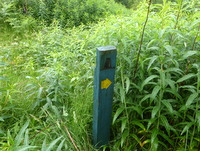 Waymark made by Tony Drake |
Note: There are many more of my photos taken in better weather conditions on the Cambrian Way website
The problem I had today was not finding the way, but finding that the path was badly overgrown. Had it been dry, I would have tried pushing though the undergrowth, but this was all soaking wet and up to chest height, so I would have been guaranteed a soaking had I done so. This has been overgrown previously and a group of volunteers cleared it, but this is something that needs doing on an annual basis if it is to be effective. The other option was to continue along the forest track and turn off later. There was another footpath several hundred yards further on but this was also overgrown, so I continued to where the track meets a minor road about a mile from the original turn off, then turned right down the road into Commins Coch. This added about half a mile to my walk, but I wasn't worried, as it was only a short day today and there were good views most of the way along the track now that there were not many trees to get in the way.
There is now no accommodation in Commins Coch, so I was taking the Cemmaes Variant to stay at the Penrhos Arms. This was the first time I was walking this route as, although I stayed in Cemmaes in 2010, I made a mistake thinking it was in Cemmaes Road and ended up going a long way around before I found the place. The route proved very pleasant and I sat on a conveniently located bench on the way for a drink and a snack. Before long the rain started again, so I pressed on to the hotel, arriving at about 5.00, this time not as wet as yesterday. There was an oil filled radiator in my room, so this was a good opportunity to wash things out and hang them above it to dry.
Over the past couple of days I have been having a few twinges from my right knee at times, so I had been taking advantage of the lesser daily mileages to take things more steadily. Knowing that I had a very tough day ahead on Friday I was hoping it might have a chance to recover by then.
Down in the bar, which was quite busy, I had a pint of bitter and started looking at the menu but was informed that it was Steak Night with a special offer of a large steak with all the trimmings and a glass of wine for £12.99. This seemed like very good value, so I ignored the other menu options and ordered that and it was excellent. I had been worrying that the batteries in my GPS would not last for the rest of the walk and hoping that I might pass a shop to buy some more, but there had been nothing on the way, so I asked in the bar if they had any. The girl went off and found me a couple for which I was grateful, but I realised that they were not alkaline so would have a very short life in my GPS. However, it was better than nothing, and I don't think I was charged for them on my bill. A few of the other diners were walking Glyndwr's Way which passes not far from here, so I chatted to them for a while before heading off to bed.
[Index of Walks]
[Previous]
[Top]
[Next]