Coast to Coast Walk 1992

Author: George Tod
This walk is illustrated with photographs. Click on small photo to enlarge in situ, or click caption to enlarge into new window.
Coast to Coast Walk 1992 |
||
|
Author: George TodThis walk is illustrated with photographs. Click on small photo to enlarge in situ, or click caption to enlarge into new window. |
|
| Part 3 - Patterdale to Keld | ||

[Index of Walks]
[Previous]
[Top]
[Next]
[Index of Walks]
[Previous]
[Top]
[Next]
The day started off fine and clear with a pleasant breeze, although a few clouds appeared before lunch time but cleared away in the afternoon. The blisters on my feet were getting better - the big blister on my right heel from the first day was virtually healed and the smaller ones from the second day were greatly improved. After a few days of walking the balls of my feet were beginning to ache, but they were worse than that before I even set off on the Pennine Way.
![]()
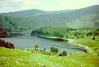
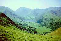 Brother's Water & Kirkstone Pass |
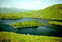 Angle Tarn |
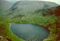 Blea Tarn & Harter Fell |
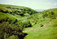
There were some very good views of Brother's Water on the way up to Angle Tarn, and more fine views from the Straits of Riggindale looking over towards Hawes Water. I decided to take a walk to the summit of High Street as the weather was so fine, so left the rucksack with note attached whilst making the detour. The extra walk was well worthwhile as it gave a lovely bird's eye view of Blea Tarn and Riggindale from one side and Hayes Water from the other. After lunch at 1 p.m. on Kidsty Pike I set off again at 1.30 p.m. The packed lunch from some hostels leaves a lot to be desired - this one consisted of 1 cheese roll, 1 packet of crisps, 1 United bar and 1 apple - not very good value for £1.90.
![]()
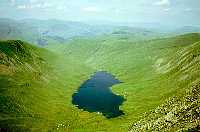 Hayes Water from High Street |
 Hawes Water from Riggindale |
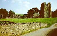 Ruins of Shap Abbey |
The walk down to Hawes water was fairly steep and the route along the lake was fairly pleasant to start with, but became rather a long drag after a while. At the end of the lake was a house with a lady doing a roaring trade selling mugs of tea to walkers. The route then followed streams and went across meadows to eventually arrive at Shap Abbey and from there along the road to Shap, where my B&B was right at the entrance to the village. At Shap Abbey I caught up with a young couple who I had met several times before. The chap was limping, having had a problem with his knee. Fortunately, though, he managed to continue and complete the walk with a bandage without having too much trouble.
![]()
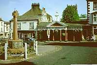
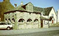 Market Cross, Shap |
The lady at the B&B gave me a very welcome pint glass of
cool orange drink when I arrived, as it was so hot. Having
showered and changed, I set off down the village in search of a
meal. There was a fish and chip cafe and inside were Graham,
Brian and Henry, so I joined them and had fish, chips, peas, tea,
bread and butter with ice cream to follow for £3.65. Later I
went down to the pub where a large number of Coast to Coast
walkers were gathered.
[Index of Walks]
[Previous]
[Top]
[Next]
Had breakfast at 8 a.m. There were no other walkers at the B&B, only a couple of chaps on their way to Scotland. After calling at the shops to buy things for lunch I set off at 9.10 a.m. It was very easy and pleasant walking country with beautiful weather. There were not a lot of features to the landscape but there were views of the Pennines to the east (Cross Fell, Great Dun Fell etc.) and the Howgill Fells to the south. Much of the walk was over a velvet carpet of grass which was very easy on the feet. With 22 miles to walk it was necessary to press on at a reasonable rate, so the first stop was after 5.5 miles at 11.15 with a quarter of the distance done. After a snack and half hour rest I set off again towards Orton. I managed to find the first bit of off-road alternative leading down through meadows with masses of wild flowers and then following a stream into the village. I only wish I could identify some of the flowers - there seem to be a greater variety than around home, possibly because the meadows have not been treated with herbicides for some years.
After Orton came a long stretch of road walking. This part of the route was hastily put in as an amendment to Wainwright's original route because the path over Orton Scar was not a right of way. A couple of footpaths have recently been defined and avoid much of the road walking, but I didn't see these until I had passed the points where I could easily join either of them, so ended up walking along the road. At least the road was quiet and there were pleasant verges, with a host of wild flowers to look at, but it was still a bit tedious. I stopped for half an hour for lunch and a `boots off' rest at 1.30 p.m. just past the day's half way point and sunbathed. There was not a cloud in the sky and it was starting to get quite hot.
After another 1.5 miles of road walking I reached Sunbiggin Tarn which was threshing with wild fowl all making a heck of a din. The area around there is also noted for rare plants and there were ladies searching for a particularly rare species of fern which had been sighted nearby. The route then, at least, was off the road and pleasant, but became a bit of a drag with so many miles to go and not many interesting features to break up the walk. I stopped again at the three quarter way point at 3.45 p.m. and aired off my feet again. By this time the full heat of the day had built up so I even resorted to resting in the shade. I had a drink of hot orange from the flask that had been on the sunny side of my rucksack and a drink of warm orange from the flask on the other side. As for my chocolate biscuits, they were just a molten sticky mess. I set off again at 4 p.m. and the scenery soon became much more interesting as I entered Smardale with its pack horse bridge, old lime kilns, ancient settlements and railway viaduct. I arrived in Kirkby Stephen at 6 p.m. and went into church for the night! - the Youth Hostel there is a converted church, there being something of an excess of churches in the town. The evening meal was good with 4 choices of main course - I had soup, cornish pasty and rhubarb pie with ice cream.
![]()
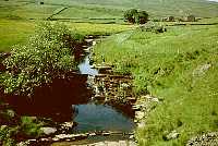
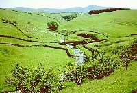 Smardale Bridge |
 Smardale Gill |
Graham, Brian and Henry had been shopping around town and two of them had bought ex East German army shirts for £1 each. Graham soon started to realise that, much as it may have been a bargain, it was also extra weight to carry for over 100 miles, so he started trying to sell it again for 50 pence. When this didn't work he ended up by giving it away to a New Zealander in the hostel. Brian, however, carried his all the way to Robin Hood's Bay without once wearing it. The irony of this being that the three of them were returning to Kirkby Stephen at the end of the walk to catch their train back to London, having used the Coast to Coast transport service to get them from there to the start, and back from the finish. The three of them were always joking about having got all the "High Tech, Super Lightweight, Carbon Fibre......." gear to cut down on weight, with Brian saying that he had been so paranoid about weight that if a fly landed on the rucksack he had to brush it off straight away, so this made the situation even more amusing. In shopping for his equipment beforehand, Brian, who had recently been made redundant, bought a waterproof jacket for £180 and made the mistake of leaving the receipt around for his wife to find. Not surprisingly, she was not amused. It rained very little on the walk so they reckoned that it had cost about £10 a minute for the use he got out of it.
Later in the evening I met Graham, Brian and Henry again, plus others, in one of the many pubs in town. Graham kept telling the tale of his wife having given up after 40 miles of the 46 miles of the Peddars' Way because she got a blister, and in some of the banter about Northerners vs Southerners, Brian remarked "I suppose that, if you Northerners get blisters, you just sew some pieces of Brillo pads into your socks!".
[Index of Walks]
[Previous]
[Top]
[Next]
![]()
 Market Square, Kirkby Stephen |
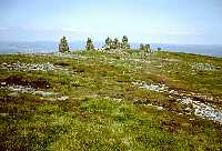 Nine Standards Rigg |
 Waterfall near Raven Seat |
Started off the walk at 9.45 a.m. on what looked like another scorching hot day, although there was, at least, a bit of a breeze on higher ground. I met up with a group of about 10 policemen who were walking the Coast to Coast, but they were not as friendly as most other people. Some of them seemed to be struggling a bit in the heat despite the fact that they were not carrying packs, but had had their gear sent ahead. There was a steady climb up to the summit of Nine Standards Rigg at 2171 ft above sea level, which I reached at 11.45 a.m. There was a large crowd at the summit and I spent about an hour there, as there was not a lot of distance to walk that day and the weather was very pleasant. The view was slightly hazy, but Great Dun Fell, Great Shunner Fell, Tan Hill Inn, Sleightholme Moor, Bowes Moor etc. on the Pennine Way could be clearly seen, although it was not quite possible to see back to the Lakeland Fells. Again, because I had plenty of time, I spent about an hour on the descent sunbathing. I had to put my T shirt back on, though, because my shoulders were starting to get a bit sore where the rucksack straps were rubbing against the sunburn. The scenery was a complete contrast to the steep and rugged crags of the Lake District with miles and miles of open moorland. There were a number of picturesque little valleys with streams and waterfalls to break up the monotony of the moorland scenery, however.
After a leisurely walk with more stops in the sunshine, I arrived at Keld Youth Hostel at 5.10 p.m. I was glad to see that the rather creaking bunk beds of the previous year had been replaced or repaired. What seems to have happened in most hostels is that the old bed springs and wire supports underneath the mattresses, half of which tended to be broken, have been replaced by wooden boards. This avoids all the sagging and creaking, but leaves only the fairly thin mattress to provide any degree of softness. Still, you can't win them all!
It appears that the group of policemen, who had been intending
to walk right on to Reeth, had found the going and the heat too
much for them and dropped out at Keld. They had sent all their
packs ahead to Reeth, so had to phone up a friend with a minibus
to collect them. So much for the calibre of the modern police
officer! They had also been seen earlier by some of the others
outside a cafe, where some of the younger ones were kicking a
football about and generally making a nuisance of themselves
until they were told off by their sergeant.
Keld is the crossing point of the Pennine Way and the Coast to Coast walk and roughly the halfway point of each, so it seemed strange that there were no Pennine Way walkers in the hostel that evening. Brian, being confronted with a potential disaster situation of having no pub in the village, was busily trying to eye up anyone who might provide a lift to the nearest pub, 3 miles away in Muker. He met with no success, so he, Henry and I decided to walk there immediately after dinner. An American young lady staying at the hostel was totally incredulous that we were prepared to walk over six miles just to get a drink! However, neither the present day's walk nor the next day's were very long, and it was a pleasant midsummer evening with daylight lasting until well after 10 p.m. Also, the route to the pub was along a valley of outstanding natural beauty, so it was well worthwhile doing apart from the prospect of a few well-earned pints of beer.
Dinner was soup, cottage pie and sponge pudding and was
finished in fairly good time so we were able to set off for Muker
at about 7.45. I took them along the Pennine Way route, which
gives a fine view across upper Swaledale, but which runs fairly
high up the side of the valley and was rather rocky under foot
and, therefore, not a good route for the return journey in the
fading light of day. They both swore that they wanted nothing to
do with the Pennine Way after that. We reached the pub in just
one hour, so set off back at 10 p.m. having been advised to take
the better footpath on the other side of the valley. This meant
first finding the footbridge across the river Swale and, as our
first attempt was along the wrong route, we wasted about 10
minutes retracing our steps. Having then found the right path and
walked at a very brisk pace we arrived back at 11.15 p.m. as the
route, though easier, was about half a mile longer. The last
traces of twilight had all but disappeared by the time we got
back and we had to resort to torchlight for the last part of the
way. Brian had been told that warden wouldn't lock up until 11.30,
but the door was already locked when we arrived (the official
locking-up time being 11.00). However, the warden let us in with
a rebuke so we did not have to bring into action the contingency
plan of using the fire escape to the second floor.
[Index of Walks]
[Previous]
[Top]
[Next]